24 February 2023

German Settlements in Ukraine

Between 1766 and 1918, Germans were known to have lived in close to 3,000 places in within the borders of Ukraine today, in both urban and rural settlements. Many were established by Germans after 1804. These places—whether they still exist or not, whether their names are the same or not—remain in the hearts of the descendants as one our ancestral homelands.

Slava Ukraini!

🇺🇦🌻


# # #


19 February 2023

Update: Eastern Siberia and Far East Russia


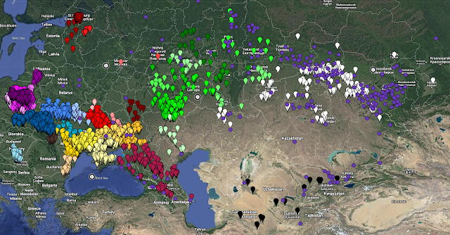
A productive first week of splitting of Asiatic Russia into its former imperial provinces. The work has been less splitting and more locating. Starting in Eastern Siberia with the province of Irkutsk and working my way east into the Russian Far East, a total of 38 new locations were added, mostly from the 1897 Imperial Census, but quite a few came from EWZ files. These are all non-German founded settlements where German people were reported to have lived, or they themselves reported being born there. Some were voluntary, but I have to assume that some were involuntary the further east I went, and the more EWZ files as the primary source for place names started showing up.

Completed are the province/oblast/regions (as of about 1914) of Amur, Irkutsk, Kamchatka, Primorskaya, Sakhalin and Transbaikal.

Next, I will be moving into Western Siberia and south into the Steppes Krai using the same methodology. There will undoubtedly be more location additions with each province. Everything will be posted once all of Asiatic Russia has been done. It has to be an all or nothing post given my propensity to push the limits of Google MyMaps. I think it will be worth the wait. 

Have a great week!

# # #


11 February 2023

Mappy Birthday!


Before I get into the notes of this month’s release, I’d like to take a moment to do my annual “how it started” and “how it’s going” look back on this project. 

This is how it started on 11 February 2016:

And this is how it’s going on 11 February 2023: 


The map refresh before Christmas last year left a few things outstanding that have been dealt with in this weekend’s update. 

There were 72 settlements that were outstanding for verification in the Samara province that have been confirmed and fully documented. These were mostly established in the Soviet era. Because I was in the neighborhood, an additional 42 settlements were added as I went through the Stumpp map by section. Many of them were chutors/khutors, collectives and state farms; some only appeared by name on one map other than Stumpp’s. 

The imperial Samara province was dissolved in 1928, so all those settlements with populations recorded in the 1924 census are recorded with their imperial district/province. Anything established after 1928 do not have the district and the province is asterisked to note that’s for categorizing these settlements together with those in what is the former Samara province at that point. 

I did have difficulty confirming some settlements as part of the “Volga German enclave” because they appeared during the interwar years (1918-1939). I hesitate to make the assumption that because they were near other Volga colonies that they were indeed “Volga German.” I did my best to not assume, but rather, try to find a source or a site that was researching them as Volga German settlement. Therefore, if you are looking for places where Volga Germans lived during the interwar period, you are strongly encouraged to use the Samara and Saratov province maps or the regional map instead of just the Volga enclave map. As always, if you don’t find what you’re looking for, let me know, and I will try to find it for you. 

The “About” pin has been updated to include the Black Sea German Research (BSGR) website. Germans from the provinces of South Russia migrated north to the Orenburg and Ufa provinces, and there are some recent Catholic church record translations available at BSGR for the Chelyabinsk and Orenburg parishes. They also have EWZ indexes in their database with hundreds entries from both EWZs and donated GEDCOMs that refer to settlements in the provinces in this region. BSGR is a real sleeper site of information. Spend 3 minutes searching the database and the website for things you are sure are not there, and prepare to be pleasantly surprised.

In December during my annual clean-up-my-downloads-folder event, I posted on social media about 14 German chutors in Tsarev District, Astrakhan Province...later the Stalingrad Oblast after the imperial province was dissolved, today in the Volgograd Oblast. Someone’s grandmother was born there was able to confirm that the German origins were linked to Dobrinka and Galka. I like when things like that happen, when the story behind a pin is suddenly revealed. Those settlements have been updated with that information.

All of the relavant maps have been updated. The sources page has been updated to reflect additions or updates. Someday I will annotate this list. It is a good list. And the change history log has been updated with a full list of settlements updated and added. 

Next up, I will be splitting the settlements in Asiatic Russia into their historical imperial provinces as they were circa 1914 toward the end of the empire: Siberia and the Russian Far East (11 provinces), Steppes Krai and Russian Turkestan (11 provinces), and the Caucasus Viceroyality (14 provinces). This is the last region where I need to do this exercise. I did some preliminary planning already, so I know where I am headed and what it will take to get there. Like the other regions, it is an all or nothing effort. Nothing will be posted to the map until the split is complete. I fully expect this to be ready before conference season starts in July.

Until next time, enjoy!

# # #