14 December 2022

It's been a busy year.

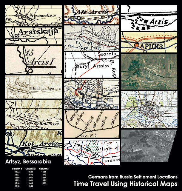
Germans from Russia Settlement Locations map as of December 2022

With convention and presentation season over late last September, I dove back into research again. The maps have all been updated as well as the sources and the change log. This is the last update for this year. 

This time, the focus was on East Russia: that is, the eastern part of European Russia, the Volga German colonies and the surrounding provinces. I had a few requests to address the Samara/Saratov province split in 1850, so I did a similar exercise that I did with South Russia last year: disassemble the entire region completely and put it back together in the provinces as they were at the end of the Russia Empire. Each colony in the region was revisited and revised and notes added to help the researcher fill in the blanks depending on when their ancestors resided in these places. Period geolocated maps were used to place them accordingly. The same was done for the Orenburg/Ufa province split. There are still 72 outstanding Volga colonies because there was not enough time to finish them all before the holidays. They were all established in the Soviet era with founding years in the 1920s or unknown years. Those will be in the next update prior to RootsTech in March. 

Unlike most maps, this map is that it is not just a single snapshot in time drawn with data that might be a few years old already, like most maps. It is a cumulation of centuries of data on one single map. It is impossible to include every administrative variant that transpired over the years, but I am trying to put what makes sense to help guide researchers on their journeys. 

One piece of information I have altered in the Volga colonies is the German origins. I had been going through the confirmed origins on The Volga Germans website and listing out the origins for each colony. But Maggie Hein and her crew of researchers are difficult to keep up with. All kudos to them for just doing what needs to be done and sharing it freely with everyone. For now, I've added links to the colonies from their website instead of listing out the places in Germany that have been confirmed. As much as I would someday like to be able to search the map for a Germanic origin and see all the colonies in Russia that had people come from that place, for now it is not feasible. If anyone has time on their hands and would like to take on this data collection, let me know. 

Also in this release are updated notes on the occupation of Ukraine by Russia. Because this is a living document (continually edited and updated as research progresses and as current geopolitical events occur), the former German settlements that are in Russian occupied Ukraine are noted as such. I happily removed some of those notes this time around, but not enough of them, in my opinion. An easy way to find these is to search the big map for “Russo-Ukrainian” (no quotation marks) to get a list. The first time I noted these on the map, I had to use a number of sources to draw my own front line through a copy of my map. Since then, the good volunteers with GeoConfirmed have been keeping up an easily searchable map (by latitude and longitude instead of the other way around) with a current frontline. 

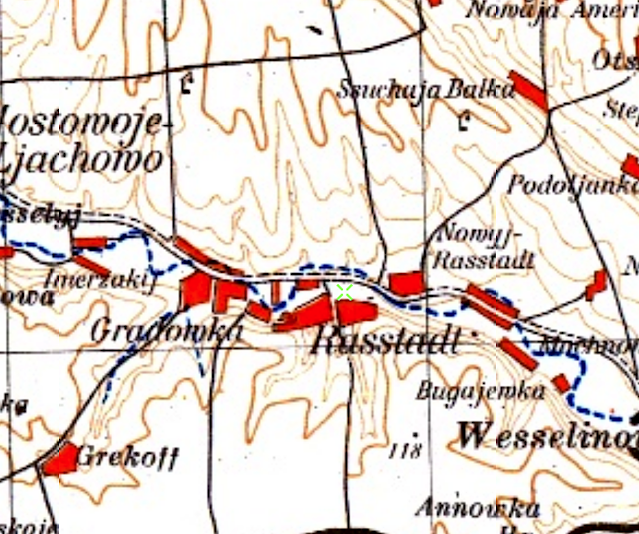
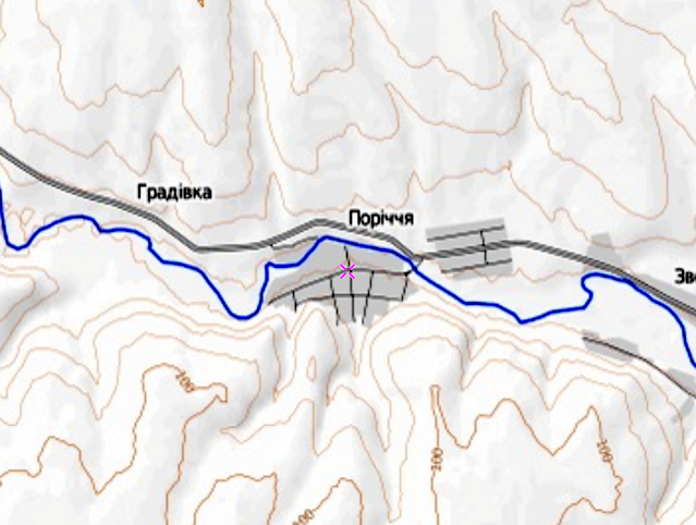
In addition, there have been a few locations added to the former Kharkov Province with more pending. Some of these originated from the First Imperial Census of 1897 wherein native languages were recorded, giving me insight into where there were German speakers at that point in time. Knowing the provinces, districts and cities were German speakers were has become a jumping off point for further searches of EWZ indexes on the Black Sea German Research (BSGR) database along with its full database of donated GEDCOMS. Within it, I can search by place and sort by date to generate a list of places and the earliest known recorded births in each place. Do not let the term “Black Sea” mislead you into thinking you will only find Black Sea German information on that website or in the database. Our ancestors moved far and wide. Recent translations of parish records released by the researchers at BSGR show this. If a Black Sea German family moves to Chelyabinsk, are they still Black Sea German? If a tree falls in a forest...well, you get the idea. The Society for German Genealogy in Eastern Europe (SGGEE) master pedigree database is another source I use in the same manner. This one is restricted to members and has the place names normalized. I never know what I might find until I start searching these pedigree databases; knowing what to search for helps. I hope that someday there will be a similar effort to collect donated GEDCOMS from Volga Germans and put them online, either free to the public like BSGR or a part of a membership. It’s long overdue, really. Also, as long as I’m asking for things in my Christmas stocking (I have been very good this year), please include a search and/or sort by place name option. Thanks, Santa. 

I have started to make a list what I would like to work on in the coming year. Somehow the list of things to do never gets shorter. I am so very lucky that I am never bored. 

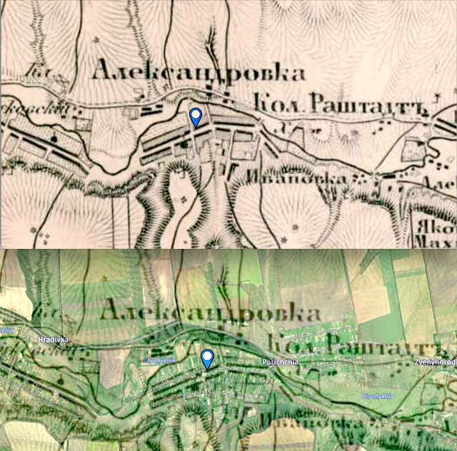
One domestic (?) project that I will be working is a map of first families in the historic Beaver Creek area of Dakota Territory. When Michael Miller sent out his December issue of In Touch with Prairie Living, it included excerpts of the "Fischer Family Chronicle," which had been donated to the Germans from Russia Heritage Collection archive. The Fischers, landing first in Yankton, but eventually settled in the Beaver Creek area now in North Dakota, same place as my great-great-grandfather, Ludwig Erck, in 1886 and my great-grandfather, Johann Schilling, in 1898. George Rath in his book, The Black Sea Germans in the Dakotas, mentioned the “so-called Beaver Creek area,” the area where Catholic Germans from Russia first settled in Dakota. A while back, I put together a map to try to figure out exactly where exactly the settlement of Beaver Creek was based on what was in Rath’s book and and other sources that mentioned Beaver Creek in North Dakota. There were several townsites called Beaver Creek, but none of them developed into actual towns. I shared the map, and there was some interest from those who had ties to the area. So, I will be putting together a plan to collect data to map, and hopefully descendants of those who settled there will be able to contribute some of their time, knowledge, and maybe some scans of documents and photos to the project. I will post the plan here when it is ready to go. If anyone is interested in participate, please let me know. Although it may only be an interest to a few, it might serve as a map model for other small historic GR areas in the future. 

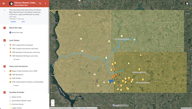
Beta version of Historic Beaver Creek.

That’s it for 2022. I wish everyone a Merry Christmas and a Peaceful New Year. May all your days be merry and bright.

— Sandy

# # #


04 October 2022

1937-38 Collective Farms & Agriculture Maps

Below are several related to collective farms (kolkhozes) in the Soviet Union. I happened on them while exploring the beta version of the National Archives and Records Administration (NARA) catalog. 

These are all declassified CIA maps apparently produced from data collected between 1937 into the early 1950s. Some of our German ancestors, of course, lived and worked on these farms up to WWII, and some continued to work on the state farms (sovkhozes), which were more prevalent in Kazakhstan and Central Asia, after being resettled. The maps were produced after the Holodomor, the Great Famine. Perhaps it was a lessons-learned exercise on the part of the U.S.? NARA does not offer any context, explanation or other information about the maps. But among them is a series of maps that offers “computed production” — what could be produced on the farms given the acreage that could be planted and harvested within the estimated dates, and, presumably, if the farm land was managed well. 

While these maps don’t have German colony names on them, I still found them to be interesting. They led me to learn more about Machine Tractor Stations (Машинно-тракторные станции), which I had not heard of before. I almost disregarded that map entirely in favor of the crop maps until I looked into the subject further and realized it was a key part of the bigger story of collective farms.  

During the early days of collectivization (1929-30, Machine Tractor Stations (MTS) were established and tasked to acquire, maintain and provide tractors and other farm machines to collective farms in an area with the idea that it would modernize farming in the Soviet state, especially for peasants who often didn’t own such equipment. However, farming was already modernized in the German colonies, whose farmers owned tractors and other farm implements, particularly in the Mennonite settlements. Waldheim in the Molotschna Colony was home to the I. I. Neufeld & Co., a farm equipment manufacturing company who had been producing farm equipment since 1890. Look at any of the old Volkskalendars and newspapers before the fall of the Russian Empire, and you will see many advertisements for farm equipment for sale, including U.S. manufacturers. The inventory of farm equipment in the MST initially came from (confiscated from) prosperous individual farmers (kulaks) which was then turned around and rented back to the collective farm. Often finding tractors and other equipment in the MTS in disrepair, German farmers ended up resorting to using horses and cattle (for as long as they lasted) to bring in their crops in the early 1930s, leaving some of the crops on the field. MTS also served as political centers that oversaw the farms and made sure their obligations to the state were made in a timely fashion. They also made decisions on the timing of seeding and harvesting. These decisions were not always based on good agricultural practices.

The first MTS was established at the Shevchenko state farm in the late 1920s, which was in the same district as the Beresan colonies. Ulrich Mertens’ German-Russian Handbook notes the demise of the MTS (p. 121) and indicates which colonies had collective farms, but it does not mention where the MTSs were located. Unable to find a definitive list of MTS locations (Russian Wikipedia states they were “created everywhere”), accounts by German-Russian descendants and scholars noted they existed in Speyer (Beresan) and several of the Mennonite Colonies including Orloff (Molotschna), Halbstadt (Molotschna), Waldheim (Molotschna) and Chortitza (Chortitza). The website Wolgadeutch has an article and a map (unfortunately not very readable) about MTS in the Volga German ASSR.

If interested, here is some additional reading material on the topic: 


Below are the maps from 1937–38 along with their original source URLs. I have cleaned up the images, and they are all available along with some later maps and soil maps of Ukraine in a photo collection here. Visit the links below to see and obtain the originals. 

_______

European USSR: Collective Farms, Proportion Services by Machine Tractor Stations, 1937

_______

European USSR: Sown Area by Types of Farms, 1938
_______

Major Areas of Oats in the Soviet Union, 1938. Approximate seeding and harvesting dates.
_______

Major Areas of Rye in the Soviet Union, 1938. Approximate seeding and harvesting dates.
_______

Major Areas of Spring Wheat in the Soviet Union, 1938. Approximate seeding and harvesting dates.
_______

Major Areas of Winter Wheat in the Soviet Union, 1938. Approximate seeding and harvesting dates.
_______

European USSR: Sown Area of Flax, Sunflowers, Sugar Beets, and Hemp, 1938
_______

European USSR: Sown Area of Wheat and Rye, 1938
_______


European USSR: Crops Percentage of Distribution, 1938 (wheat, vegetables, potatoes, forage crops, fibers, oilseeds, sugar beets, tobacco, spices, medicinal crops)

For additional maps like these, see the photo collection here.

# # #


01 October 2022

Traveling with Texan GRs Through Time

1765 map showing Dobrinka.

I had a fun time last weekend traveling back in time with the members of the North Texas Germans from Russia AHSGR/GRHS duel chapter over Zoom. Several members offered up their ancestral colonies prior to the presentation, so I was able to customize it a bit for the group using the colonies to which they are connected.
 
We divided our time between the Kherson and Saratov provinces. We wandered around some of the Glückstal colonies (Glückstal, Neudorf, Bergdorf, Hoffnungstal), then went down to the Kutschurgan enclave to visit the Mother colonies and a few of the Daughter colonies that were established by 1872 (Strassburg, Baden, Selz, Kandel, Elsass, Mannheim, Johannestal, Georgental, Nikolastal), and then on to a few of the Mothers and Daughters in the Beresan enclave (Rohrbach, Waterloo, Speyer, Johannestal, Worms, Neu Klatscha, Neu Kandel, Uljanowka, Neufeld, Friedenheim, Neu Rohrbach). We went back and found the elusive Chutor Balitsky, which appeared on maps as its Russian name, Saratow. We popped in on Dobrinka circa 1765 over in the Volga enclave. That was fun. Then we went up to Neu Messer and checked out the neighbors in 1910 (Walter, Frank, Kolb, Neu Blazer, Neu Dönhof, Norka, Huck). We found that map's purpose was to show phosphorite deposits. Amazing what you learn when you zoom out.

02 August 2022

Conference Presentations 2022


I had a great time presenting “Time Travel Using Historical Maps” at the 52nd Annual American Historical Society for Germans from Russia International Convention last week. I joined other Zoom presenters from Argentina, Germany and the United Kingdom in the virtual lineup of the program. 

Next up, I will be giving a longer (90 minutes), more in-depth version of the same material at the GR Wall Breaker Conference (September 9-11th on Zoom). The schedule is not locked down yet, but these are all the presentations/topics scheduled at the moment: 

    • Genealogy in Ukraine: Discover Online Resources
    • International German Genealogy Partnership
    • By the Sweat of Their Brows” Researching to Discover the Work by Which Your Ancestors Made Their Daily Bread
    • Stumpp and Search: Demonstration of how to use the fantastic Dr. Karl Stumpp Book and advanced search techniques for Google
    • Cadastral Maps and their Ancillary Records
    • Researching Your Russian-German Genealogy in Russian Archives 
    • Time Travel Using Historical Maps
    • How to Make Nockerl with Bacon in Scrambled Eggs 
    • Warrants & Patents & Deeds, Oh My!
    • Historic Newspapers: Our Story Has Always Been Told
    • Using Google Drive for Genealogy
    • Developing a Sixth Census: Finding more in “the Census” than meets the eye
    • EWZ! Diving Into Researching Using EWZ Records
    • Going from the EWZ into family
    • Unique Finds
    • Changing Churches
    • Moravian Faith 101+ Archives
    • Black Sea German Research updates
I will also be presenting at some AHSGR/GRHS combined chapter meetings in the fall. 

# # #


22 July 2022

First Colonies Established After the 1763 Manifesto

Today is the anniversary of the issuance of Catherine the Great’s Manifesto of 1763, where she invited foreigners to settle in her empire. It was the origin story of German settlement in Russia.

While the majority of the colonies were established along the Volga river in the Astrakhan Province (later Saratov Province), there were other groups and solo colonies established at the same time. Five Mother colonies were founded near St. Petersburg, and these would spawn daughter colonies in both the St. Petersburg and Novgorod provinces.  Six Belowesch colonies were founded in Chernigov Province. There were a few daughter colonies in the same area, but some of the Belowesch daughter colonies were established in Ekaterinoslav Province. Riebensdorf was an isolated colony in Voronezh Province, between the Belowesch and Volga enclaves. At least 14 daughter colonies were established not near Riebensdorf but in the Don Cossack Host, the North Caucasus, and in Siberia. Sarepta was another isolated colony south of the Volga colonies but also on the Volga River near Tsaritsyn (later Stalingrad and now Volgograd).


# # #

21 June 2022

City of Kherson Through Time

1910 Map of the City of Kherson.

On 18 June 1778 (uncertain if this was the Julian or Gregorian date), a decree was issued by Catherine the Great founding the city and fortress of Kherson (Ukrainian: Херсо́н, German: Cherson) on the Dnieper River. It was to be the central command of the Russian Navy’s Black Sea Fleet.

German colonists immigrating to Russia in the early 1800s who were not farmers had the option settling in cities:

“For the initial founding of colonies in Cherson, Ekaterinoslav, and Taurida Gubernias to select locations mostly near ports in order that the settlers can be located with a particular means to get their products out....Artisans and craftsmen of all types are to be settled in the cities, wherever each one wishes. But in the first instance the present arrivals [February 1804] from Germany will be based in Odessa because Collegial Councilor Kontenius has been permitted to get this process started....” 

German colonists in Russian cities were a minority population. In 1897, with a population of 59, 076, just .7% of the population of the city of Kherson spoke the German language. 

There was a Catholic parish in Kherson with a stone church. In 1904, there were 1,209 souls, and according to Joseph Schnurr, most were Poles. 

Like with most cities in the former Russian Empire, it is difficult at a glance to say exactly when German colonists may have lived there. Kherson is a city, a former district, and a former province. Like Odessa, Kherson shows up in in family trees and EWZ records without any indication if it was the city proper, the district, or the greater province. 

A search of Kherson/Cherson as a birth place in the Black Sea German Research database indicates that the children of German colonists were born in Kherson/Cherson (city? district? province?) between 1808 and 1943. This happens to correspond with the early years after the Black Sea area was made available to foreigners for settlement (1804) and also the later years of when EWZ records were taken (1939–early 1945) for those ethnic Germans who were resettled back to Germany.


Sources and Further Reading:

# # #

18 June 2022

Christina Through Time

In search of locating the earliest map of the Beresan Catholic daughter colony Christina (today Novosafronivka, Mykolaiv Oblast, Ukraine) by its coordinates, I noticed something: the name “Christina” did not appear on maps until the 1940s.

Reportedly founded in 1874-75 or 1878-79 (German Captured Documents) or 1891 (Mertens and Ortslexikon), the oldest appearance of the village by its name Sofronowka that I found initially was on an 1860 map.

A quick search of the Black Sea German Research database confirms people were born in Christina in between 1860 and 1943, not only in pedigrees but also in EWZ records. Earliest death in the same database was 1875. Another search for Sofronowka shows even more between roughly the same years, most of which called the place Nowo-Sofronowka. 


I began to look for Sofronowka/Christina on older maps and found it on ones from 1805 and 1796, before Germans were settling in the Black Sea area. Certainly before there were any daughter colonies. 

I searched the Ukrainian language version of Wikipedia for its current name, Новосафронівка. It said the village was established in 1796, matching the publication date of the oldest map, and the sign on the way into town

Further into the German Captured Documents is a page about the history of Sofronowka:

Sofronnowka. 

     Some of the German inhabitants come from the Rhine Palatinate and Alsace. Some of the old landlords emigrated to Germany, Serbia and Bulgaria in 1918. S[ofronowka] used to be a rich village; the least landlord in the village owned 15 ha [hectares, ~37 acres] of land, the second least 25 ha [61.78 acres]. The richest landlord, Jakob Loron, had 300 ha [741.32 acres]. The village had to endure several waves of persecution because of its wealth. In 1918, the villagers often left their belongings in a bundle and fled. At the bridge of Vossnessensk, some Germans were murdered in a cruel way by the Bolsheviks (sawing off hands, cutting out eyes etc.). Some Germans had stayed behind to protect the goods of the fled landlords. They took care of the cattle, etc. Franz Reisenau and Alexander Schüler from S[ofronowka], about 30-32 years old, were shot as spies by the Reds while protecting the estate. At the mill in S[ofronowka] a Hertner and others from Felsenburg who had been taken to S[ofronowka] were shot. 

     The second persecution started in 1930. A number of ethnic Germans were forcibly resettled to Arkhangelsk. The third wave of persecution began in 1937. A number of ethnic Germans were arrested and sent away. It is not known where they were sent. This was the worst year.

     In 1941 some men were arrested and taken to Nikolaev. It is said that they were shot there by the NKVD. 

     It was founded in 1874-75 by immigrant landlords from Karlsruhe. The land was bought by the widow of a nobleman with the first name Christina. The newly founded village was originally called Neu-Sofronowka. (After the nearby Ukrainian colony of Old Sofronovka). However, a few years later a German pastor changed the name of the village, and it was called “Christina” after the widow of the nobleman. This name has been preserved in the folklore until today. The later change of the name by the Soviets to New Sofronovka did not change it.

     In 1906-07, a beautiful Gothic church was built for the Catholic community. It is said that it was the most beautiful one in the whole region. The building costs were 15000 rubles, which were raised by the community. Today the church is destroyed, but it is still possible to see from the ruins and from the whole complex that the church, situated on a dominant hill in the village, was extraordinarily magnificent. In the village there was a family who had their estates (chutors) outside and lived in the village. One of them was called Tomas Anton and he had an estate of about 1000 hectares [2471 acres].

     In the village still lives an old teacher named Johann Bär, 69 years old, who knows a little about the history of the village.

     The village today makes a desolate impression because a large number of the farms have been destroyed. The ruins still stand above all. The valley, crossed by the Elanez River, is now a wasteland. In the past there were orchards everywhere. Today the village is inhabited by 48 German families, 15 of which are of mixed marriages. There are also 11 Ukrainian families living in the village. The inhabitants are well aware of their Germanness, but they are extremely poor. The most necessary repairs have been made to the houses, and some of them have been painted and repaired. However, due to the fact that the old dilapidated place and farm buildings are still standing, the village has a desolate appearance. The planned resettlement of the inhabitants to Dobroje is postponed until the morning. There is a German school in the village, run by 2 teachers and attended by about 30 students. The mayor is Rochus Müller.


Sources and Further Reading:

# # #

09 June 2022

Yandex's Disappearing Borders

Since the Russian invasion of Ukraine on 24 February, I have periodically looked at Yandex Maps (Russia’s version of Google Maps) to see if there have been any name or region changes, particularly the Russian-declared “people’s republics” in the Donbas. Surprisingly, as war experts and cartographers rushed to keep up with daily maps of the tactical borders of the war, there were no immediate changes on Yandex. 

However, this morning, I saw that Jake Cordell of Reuters and other news outlets reported that Yandex Maps has removed the international borders. Yandex Maps has seemingly removed national borders. All of them.

This was noticed around 4 June, the say after the founder and CEO of Yandex, Arkady Volozh, was sanctioned by the EU and subsequently resigned. 

Today, Yandex put out a statement saying that its main scenario/service to its users was to help find organizations, places, public transport, and auto routes. Where their main service/scenario is not used will become physical and geographical. “The emphasis will be on natural objects, not on the borders of states.” It goes on to say, “Our task is to display the world around us. Therefore, mountains, rivers, polar circles lines and other data typical of this type of maps will appear on the map. Changes will appear gradually.”

I located a screenshot of what the map looked like before and the same map today. Ignore the pins on the map, but note the lack of borders. 

Source: Google Images search for “screenshot of yandex maps”.

Source: Vue Yandex Maps Examples on CodeSandbox.

# # #

06 June 2022

Alt-Arcis (Artsyz) Through Time

I love finding old maps with the names German colonies on them. It’s like finding a baby picture you never knew was taken. You might think that every map of the Russian Empire has our German colonies on them, but the fact is they don’t. Germans were one of many ethnicities that colonized the Russian Empire, and our settlements in Russia did not always make it onto maps. 

Later this summer, I’ll be presenting “Time Travel Using Historical Maps” at the AHSGR Convention in July and at the GR Wall Breaker Conference in September. In preparation, I’ve been gathering up examples and will share some of them leading up to the beginning of convention season. 

First up, the Bessarabian colony of Artsyz, which is today in Odessa Oblast, Ukraine.

Founded and settled in 1816, Arzis (Alt-Arcis/Arcis/Arciz/Artsyz/Arssis) was originally called “No. 14.”  In 1819, according to a document from the Odessa State Archive (Fond 6, Inventory 1, File 1245), the 15 colonies in Bessarabia at that time underwent some name changes. No. 14 was named “Ivanovsky” by the Bessarabia Department of Foreign Settlers and the name “Arzis” by “the highest order.” On this document there is a Post-It (more recent research, obviously) that says, “#14 was named Johanneshort before being named Ivanovsky.” Johannes being the German version of Ivan, that makes sense. 

While I was really hoping to find a map that showed Artsyz as Ivanovsky or Johanneshort, I didn’t. The earliest I found was published 1832 from data collected in the years prior. Remember, back then it took many years to survey the land, gather data, draw maps, and have them published and distributed. The exception to this are military maps drawn during an active campaign. Those are often updated from previous campaigns.

During its existence, Artsyz has been historically a part of the Imperial Russian Empire (1816-1917), the Moldavian Democratic Republic (1917-1918), the Kingdom of Romania (1819-1940), the Soviet Union (1940-1941), the Kingdom of Romania again (1941-1944), the Soviet Union again (1944-1991), and Ukraine (1991-present). 

The image below shows just a few maps (and a couple early satellite photos) where Artsyz was named. They were drawn/published by Russia, Germany, Austria, Romania, and the United States. Most of the images below are linked to their live historical maps. Click on one and see where it takes you in time.  
To view a static version of this image, click here

Image Map


# # #

03 March 2022

German Settlements in Ukraine


Between 1766 and 1918, at least 2,876 known German settlements were established within
the borders of Ukraine today. Most were established after 1804.


# # #

24 February 2022

11 February 2022

The Technology Behind the Map

Today was the birthday of the map of Germans from Russia Settlement Locations. It was created in 2016 and had 103 villages on it.

I often think about all the technology behind this project and am both grateful and giddy that so much of it happened in my lifetime. Things started coming together in the 1990s when I was fresh out of college. I have two BAs from New Mexico State University in English and Journalism & Mass Communications. I’ve not used either professionally aside from a brief time employed as a technical writer right out of college. Computers and networking were much more interesting, and even though I worked at a newspaper once, I was in the production department tending to the old mainframe, the new Unix-based digital photo delivery system, encouraging the use of computer pagination over manual paste up, and trying to convince anyone who would listen that online news was the future. They were not ready for the future. But I was. Like most who were in what would become to be known as “Information Technology,” I bounced around at jobs, sucking the marrow out of each one and keeping notes about everything I learned. Back then, there wasn’t a degree that prepared you for real IT jobs. Technology was happening too fast, and it was thrilling to be bobbing up and down in those waves. I did stints at both universities (nurturing environment but underfunded) and commercial companies (plenty of money for tech but no sleep for me). I sailed through the dot-com bubble easier than anyone should have. Always employed, always learning, and always having fun. 

Most of the technology used in this project to locate ancestral colonies, map them, and make them available on the internet wasn’t available to civilians, wasn’t reliable, or didn’t exist in 1994 when I started researching my own family. Without going in too deep, here are just a few: 
  • Aerial & satellite imagery – geboren 1858-1972
  • Global Positioning System – geb. 1973
  • The Internet – geb. 1960s-1980s (.gov and .edu), geb. 1990 (commercial .com)
  • World Wide Web – geb. 1989 (text only), geb. 1993 (graphic web browser)
  • Google – geb. 1998
  • Keyhole Earth – geb. 2001
  • Google Earth – geb. 2004
  • Google Maps – geb. 2005
  • Google My Maps – geb. 2007
  • Georeferencing – geb. ~2008

Aerial & Satellite Imagery

In the mid-1800s, images were taken from hot air balloons. This originated in Paris by French photographer and balloonist Gaspard-Félix Tournachon, known as “Nadar”, in 1858. As soon as photography was available circa 1826, humans had an itch to get a birds-eye view of their surroundings. 

Honoré Daumier, Nadar Elevating Photography to the Height of an Art,
1862, lithograph from 
Souvenirs d’Artistes. National Gallery of Art

Beginning in the early 1900s, images were taken from airplanes. Crop dusters were used at first, but as aeronautics advanced, military planes were outfitted with cameras for reconnaissance missions.

Barnstormer Jersey Ringel with a camera on top of the wing of an airplane in flight. 1921. 

Library of Congress


In 1946, images began to be taken from suborbital flights. This time rockets were outfitted with cameras.

View of Earth from a camera on the rocket V-2 #12, launched October 24, 1946.

White Sands Missile Range/Applied Physics Laboratory. 

Smithsonian Magazine


The first satellite image was a crude image of of a sunlit area in the Central Pacific Ocean with cloud cover. It was taken August 14, 1959.

First satellite image. Wikipedia.

In July of 1972, the U.S. launched the Landsat program to capture satellite imagery of Earth. The program is still running today with the latest satellite, Landsat 9, launched in late 2021. Yesterday (February 10, 2022), Landsat 9 data became publicly available for researchers. Millions of images have been taken and archived and are all viewable through the U.S. Geological Survey Earth Explorer website.

Later that year, “The Blue Marble” was taken from Apollo 17 on December 7, 1972. 

Earth as it was seen from Apollo 17, December 7, 1972.

Wikipedia


These are some of the 6,500+ satellites orbiting the Earth right now, roughly 5,000 of which are active. This changes every two weeks or so with each SpaceX launch of its Starlink satellites. 

SatMap


Why does it matter?
  • Global Positioning System uses satellites for exact positioning.
  • Google Earth and Google Maps use satellite images and GPS.
  • All of the above are needed to visually confirm the location of German colonies that have been destroyed or abandoned. Google Earth (full version) allows one to go back in time through available images.
As you can see, the evidence of this this colony, Sivushka, south of Orenburg, is disappearing with time.

October 8, 2002
July 20, 2004

June 28, 2010

Global Positioning System (GPS)

GPS was built in 1973 by the U.S. Department of Defense for military use. It was called “Navigational Satellite Timing and Ranging Global Positioning System” or NAVSTAR GPS. It was a highly accurate navigation system to replace older systems that were affected by distance or the weather. It was for military only through the 1980s. 

A commercial version available in early 1990s in the U.S., but it was not very accurate because of Selective Availability (SA). This was an intentional degradation of public GPS signals so that it was not as accurate as the military version. 

In 2000, U.S. legislation did away with SA, and GPS accuracy for commercial use improved 10-fold overnight. The popularity of handheld GPS receivers increased. GPS is now in vehicle navigation systems, maps on smartphones, etc. The U.S. has 31 GPS satellites in its constellation. The EU’s Galileo has 28.  Russia’s Glonass has 24. China’s Beidou has 50.

Internet: a network of networks.

The Internet

While satellite imagery and GPS were maturing, so was something called “The Internet.” This was a “network of networks” that allowed computers to talk to each other. It was initially used for sharing data among researchers in government and higher education institutions.

In the 1980s into the early 1990s, Internet protocols and applications became more “human” friendly, but everything was still text based. It was also small enough that if you were on it, you sort of knew where everything was. Still, there were early efforts to corral the information and make it easier to use.
  • DNS – Number to name database (The name ahsgr.org is actually 162.242.142.236. Before they moved to their new website last December, it was 35.169.50.49. As a human, you didn't need to learn the new ip address. You kept using the name. The DNS server takes care of the translation from names to numbers for you. 
  • Email – Text-based, no graphics, no notifications, not mobile. 
  • Listserv – Subscription email list for communicating sharing information with groups. This was the beginning of the “drinking from the firehose” era of modern communication. Also, it was when I regularly started telling the librarians I worked with to please stop printing the internet.  
  • Content (No WWW yet, and I don’t remember actually using the term “content” at that point yet) 
    • FTP (used for uploading and downloading files; also a repository of said files)
    • Gopher (menu-based content server) 
    • WAIS (text-based wide area information server)
    • Archie (search engine for FTP sites)
In 1989, HTML (hypertext markup language) was invented. The following year, the internet became commercially available and the first browser arrived on the scene. The Lynx browser followed in 1992; it was still text based. No images.

In 1993, the Mosaic browser came out. It was the first web browser that could display images—verrrrry slowly, but it could do it! The first image I saw rendered was of Charon, Pluto’s moon, from a web server in NMSU’s astronomy department. Mosaic changed everything. This made the internet as a whole more attractive to everyone and commercially viable. It was not just for geeks anymore—pictures sold the internet to the public. Suddenly everything and everyone was going “on the net.” I spent several years around this time not only being a sysadmin but also teaching staff and students how to get onto the internet and how to use it for research. 

And then along came ...

Google.com November 11, 1998. Internet Archive

Google

In 1998, Google, Inc. was founded as an internet search engine company. It was not the first search engine on the scene, but today is currently the world’s most used. 

Meanwhile, in 1991, a company called Keyhole, Inc. was stitching together and georeferencing satellite imagery from Landsat with funding from the CIA. They launched a site called Keyhole Earthviewer, which was a 3D interface to the planet using satellite images, aerial photography, and GIS data. Its target market: the real estate industry, urban planners, and travelers.  

Earthviewer.com. November 30, 2001. Internet Archive.
Google acquired Keyhole in 2004 and renamed Keyhole Earthviewer to Google Earth.


    Google Maps launched in 2005, followed by Google My Maps in 2007. The idea behind MyMaps was to put map making into the hands of anyone so that they could “easily create custom maps with the places that matter to you.” The Germans from Russia Settlement Locations maps are made with Google My Maps. It wasn’t the first MyMap I made, but it is by far the largest and most complex in terms of the amount of data presented.

    Georeferencing Meets History

    Simply put, georeferencing is applying geographic information to a digital image (aerial photos, satellite image, maps, etc.) so that the image is correctly placed in its real world location. The process (again, very simply) it overlaying a digital image—say a map of the Saratov province—onto a digital map such as Google Maps and then identifying several location points on the image that correspond with the map. The accuracy of the end result depends greatly on the accuracy and scale of the image, which is why many are done as tiles and stitched together as one big map. Hand drawn maps, such as those by Karl Stumpp, are not terribly accurate. Highly detailed military maps, such as those of the Austrian Empire and the Red Army, often produce great georeferenced maps. When all goes well, you can have a historical map or image overlaid on a current map where you can search for locations by today’s name or by GPS coordinates and see it on the historical map. 

    Georeferencing of historical maps seemed to start appearing on the web in early 2010s. There are many digital maps collections that are georeferenced and free to use. What this has brought about is the surfacing of old maps that have not been seen before. Using these maps helps me find lost ancestral colonies and also find my mistakes. Once the coordinates are nailed down, it’s fascinating wandering back in time through maps of a place as far as I can go and then viewing the satellite images available for it in the not so distant past.

    1805—Rastatt (Beresan) before it was Rasatt
    Curious. Will write more about this soon.

    1872—Rastatt
    Top is the 1872 map. Bottom 1872 georeferenced map with modern map showing through. 

    1920—Rastatt

    This is from a 1941 German map
    1941—Rastatt


    1985—Rastatt


    2000—Rastatt


    2012—Rastatt

    2021—Rastatt

    End of nostalgia trip. I hope that you have a new appreciation of all the technology it took for this project to be where it is today, what it took for you to be able to gaze nonchalantly at your ancestral colonies and say, “There it is. No biggie.” I am glad it’s no biggie. That means it has become a part of your everyday life. For some, this romp though time and technology of this will be familiar. For others, ancient history...making me also, somehow, ancient. I’m cool with that. No biggie.

    ###