Bibliography
[1859] “Saratov Province Map.” 1859. EtoMesto. http://www.etomesto.com/map-saratov_1859/.
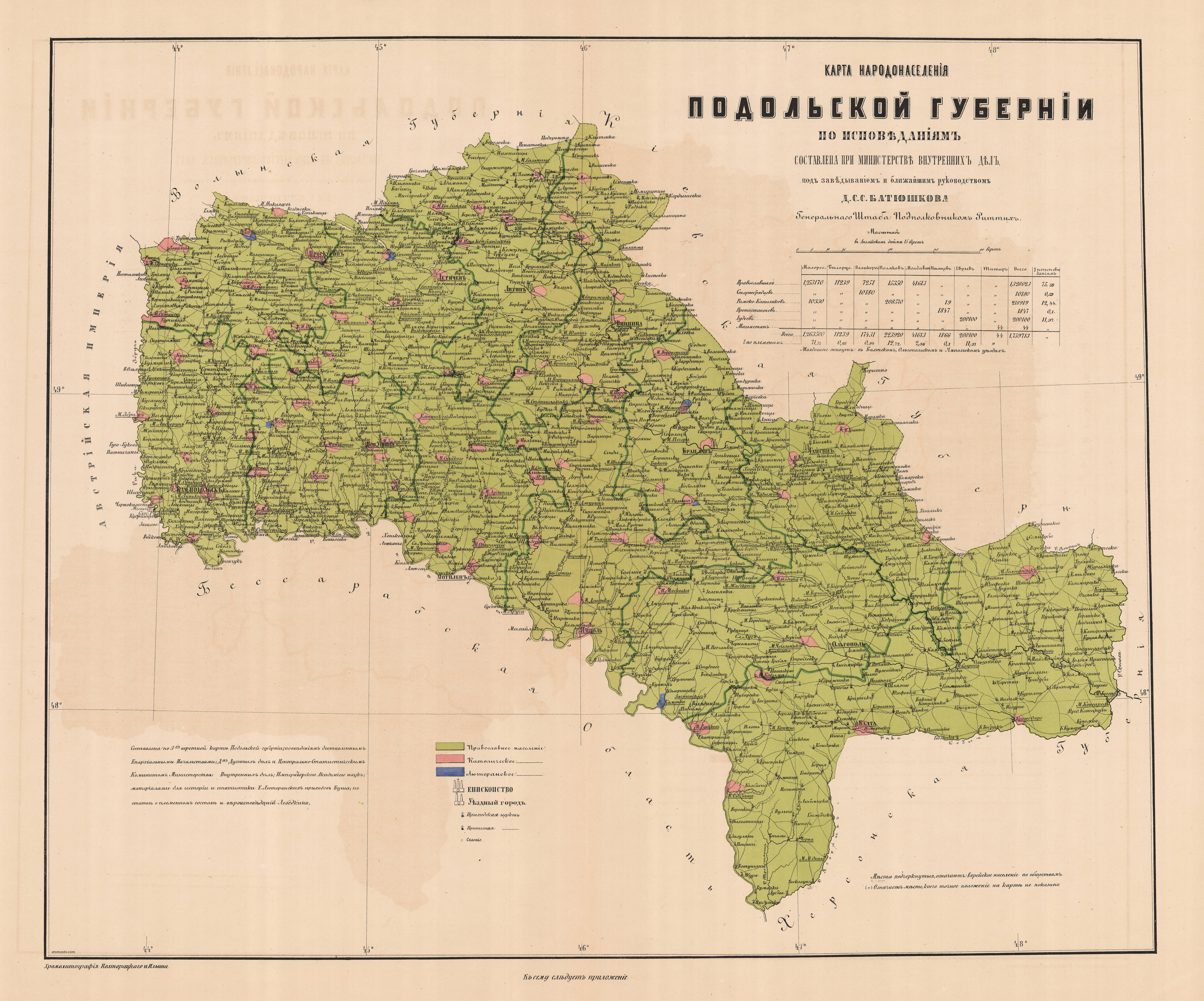
[1864] “Podolsk Province, population according to confession.” 1864. EtoMesto. http://www.etomesto.ru/map/base/100/kam-podolsk-rittich.jpg.
[1867] “Map of European Russia 1867 from Stielers Handatlas.” 1867. EtoMesto. http://www.etomesto.com/map-atlas_1867-stielers-handatlas
[1868] “Military topographic three-verst map of Moldova.” 1868. EtoMesto. http://www.etomesto.com/map-europe_moldova_trehverstovka/
[1875] “Трехверстовка Днепропетровской области. Военно-топографическая карта. [Three-verst map of the Dnipropetrovsk region. Military topographic map].” 1875. EtoMesto. http://www.etomesto.com/map-ukraine_dnepr_trehverstka/.
[1875] “Трехверстовка Запорожской области. Военно-топографическая карта [Three-verst map of the Zaporozhye region. Military topographic map].” 1875. EtoMesto. http://www.etomesto.com/map-zaporozhye_trehverstka/.
[1877] “Карта Кавказского Края 1:210К [1877 Map of the Caucasus Region 1:210K].” n.d. RetroMap. http://retromap.ru/1418772_44.661571,41.839370.
[1897] “Apostolov’s Kuban Region Map.” n.d. EtoMesto. http://www.etomesto.com/map-kuban_apostolov/.
[1903] “Roadmap of the Caucasian Territory 1903.” n.d. EtoMesto. http://www.etomesto.com/map-kuban_dorozhnaya/.
[1904] “Map of the Trans-Baikal Region, 1904.” n.d. EtoMesto. http://www.etomesto.com/map-chita_1904-zabaykalie/.
[1910] “American Map of the Caucasus [Caucasia] 1910.” n.d. EtoMesto. http://www.etomesto.com/map-kuban_kavkaz-1910/.
[1911] “Map of the Irkutsk Province, 1911.” 1911. EtoMesto. http://www.etomesto.com/map-irkutsk_1911-guberniya/.
[1911] “Map of the Melitopol District of the Tauride Province.” 1911. EtoMesto. http://www.etomesto.com/map-zaporozhye_melitopol_melitopolskiy-uezd-1911/.
[1912] “Map of the Semipalatinsk Region of 1912.” n.d. EtoMesto. http://www.etomesto.com/map-kazakhstan_semipalatinskaya-oblast_1912/.
[1912] “Map of the Ural and Turgay Regions, 1912.” n.d. EtoMesto. http://www.etomesto.com/map-kazakhstan_uralsk_oblast-1912/.
[1914] “Map of the Akmolinsk Region of 1914 by Yakovenko Publisher.” n.d. EtoMesto. http://www.etomesto.com/map-kazakhstan_akmolinskaya-oblast_1914/.
[1914] “Map of the Boundaries of Volosts of the Tomsk Province, 1914.” n.d. EtoMesto. http://www.etomesto.com/map-tomsk_tomskaya-gub-1914/.
[1914] “Map of Syr-Darya Region, 1914 [Resettlement Regions in Syr-Darya, Samarkand & Fergana].” n.d. EtoMesto. http://www.etomesto.com/map-kazakhstan_syr-darya_rayon-1914/.
[1914] “Operationskarte R - австрийская карта Европейской части России [World War 1, Topographic Maps by the Austrian Military].” 1914. Austrian Military. http://www.etomesto.ru/map-atlas_operationskarte-r/.
[1914] “The Tobolsk Province. Atlas of Asian Russia.” n.d. EtoMesto. http://www.etomesto.com/map-tumen_asia1914/.
“[1921] Map of the Strelbitsky Edition 1919-1921. East. [Карта Стрельбицкого Издания 1919-1921. Восток.].” 1921. EtoMesto. http://www.etomesto.com/map-karta-strelbickogo_ussr/.
[1924-1939] “Polish Tactical Map of Western Ukraine.” 1924-1939. EtoMesto. http://www.etomesto.com/map-ukraine_zapad/.
[1925] “Red Army Map N-43 Omsk 1:1000000.” n.d. EtoMesto. http://www.etomesto.com/map-omsk_rkka-n43-10km/.
[1926] “Карта Кавказского края [1926 Map of the Caucasus region ].” 1926. http://retromap.ru/14192611.
[1926] “Military Topographic Map of Caucasus Region, 1926.” n.d. EtoMesto. http://www.etomesto.com/map-atlas_5-verst-kavkaz/.
[1927] “Карта Днепропетровской округи 1927 года [Map of the Dnepropetrovsk county of 1927].” 1927. http://www.etomesto.ru/map-ukraine_dnepr_dnepropetrovskaya-okruga-1927/.
[1929] “Карта Луганской Области 1:100К [Map of Lugansk Region 1:100K].” 1929. Retromap. http://retromap.ru/1519294.
[1934] “Map of the Autonomous Soviet Socialist Republic of Volga Germans.” 1934. EtoMesto. 1934. http://www.etomesto.com/map-saratov_nemcy-povolzhya/?y=51.792183&x=47.258455.
“[1939] Bishkek (Frunze) and Surroundings - BSAM [Бишкек (Фрунзе) и Окрестности - БСАМ].” 1939. EtoMesto. http://www.etomesto.com/map-asia_kyrgyzstan_frunze-bsam/.
[1940] “American Military Map of the Outskirts of Omsk.” n.d. EtoMesto. http://www.etomesto.com/map-omsk_usa/.
[1940] “Map of Caucasus, Iran and Turkmenistan of the General Staff of the Red Army.” EtoMesto. 1940. http://www.etomesto.com/map-rkka_kaspiy-5km/.
[1940] “Карта РККА [1940 Map of the Red Army].” Retromap. 1940. http://retromap.ru/14194016_z12_44.140210,44.524669.
* [1941] “German Maps from Period WWII - Osteuropa 1:300000. Center.” n.d. EtoMesto. http://www.etomesto.com/map-atlas_osteuropa/.
[1941] “German Maps from Period WWII - Osteuropa 1:300000. Ural.” n.d. EtoMesto. http://www.etomesto.com/map-atlas_osteuropa_ural/.
* [1941] “L-36(A) Map of the General Staff of the Red Army (RKKA).” n.d. EtoMesto. http://www.etomesto.com/map-rkka_l-36-a/.
[1941] “Map of the Primorye region, Mongolia and China of the General Staff of the Red Army.” n.d. EtoMesto. http://www.etomesto.com/map-rkka_primorye-10km/.
[1941] “Map of the South Russia of the General Staff of the Red Army.” n.d. EtoMesto. http://www.etomesto.com/map-rkka_ug/.
[1941]“ Запад СССР - РККА [1941 West of the USSR - RKKA].” Retromap. 1941. http://retromap.ru/14194126.
[1942] “American Military Map of Primorye and Parts of Eastern Siberia.” n.d. EtoMesto. http://www.etomesto.com/map-habarovsk_usa.
[1942] “Немецкая карта Кавказа [1942 German map of the Caucasus].” Retromap. 1942. http://retromap.ru/14194228_44.291786,42.973195.
[1942] “Немецкая карта СССР [German Map of the USSR].” Retromap. 1942. http://retromap.ru/14194222.
[1950] “American Military Map of the Surroundings of Novosibirsk.” n.d. EtoMesto. http://www.etomesto.com/map-novosibirsk_usa/.
[1985] “L-36 карты СССР. Одесса, Симферополь, Севастополь, Херсон, Николаев [L-36 maps of the USSR. Odessa, Simferopol, Sevastopol, Kherson, Nikolaev].” 1985. http://www.etomesto.ru/map-genshtab_l-36/.
[1985] “N-43 Soviet Military Maps 1:200000 [Omsk Region].” n.d. EtoMesto. http://www.etomesto.com/map-genshtab_n-43/.
[1994] “Topographic Map of the South of the Omsk Region of the Ministry of Ecology of the Russian Federation.” n.d. EtoMesto. http://www.etomesto.com/map-omsk_topograph/.
“American Historical Society Of Germans From Russia.” n.d. Historical society. American Historical Society Of Germans From Russia. Accessed September 15, 2021. https://www.ahsgr.org.
Anonymous. 2020. “Abschied Fuer Immer Aus Kleinliebental Bei Odessa [Farewell Forever from Kleinliebental near Odessa].” Translated by Alex Herzog. Heritage Review 50 (3). https://grhs.org.
Asatryan, Garnik, and Victoria Arakelova. 2002. “Ethnic Minorities of Armenia.” Internet Archive. https://web.archive.org/web/20070710071814if_/http://www.osce.org/documents/oy/2002/01/148_en.pdf.
“Atlas Der Evangelisch - Lutherischen Gemeinen in Russland [Atlas of Evangelical - Lutheran Congregations in Russia].” n.d. David Rumsey Map Collection. Accessed September 15, 2021. https://www.davidrumsey.com/luna/servlet/view/search?search=SUBMIT&cat=0&q=Atlas+der+Evangelisch-Lutherischen+Gemeinen+in+Russland.
Auman, W., V. Baumgärtner, W. Brett, N. Bugaj, V. Dizendorf, A. Ehrlich, Ju. Petrov, V. Chebotaryova, and N. Vardenburg, eds. 2006. Die Deutschen Russlands Siedlungen und Siedlunngsgebiete Lexikon [The Germans of Russia Settlements and Settlement Areas Encyclopedia]. 2006th ed. Moscow, Russia: ERD. https://wolgadeutsche.net/diesendorf/Ortslexikon.pdf.
Bender, Dennis G. n.d. “Germans from Russia and Eastern Europe Settlement Locations.” Gazetteer. GRSL · DG Bender. https://sites.google.com/riehl-partner-web.de/grsl-daten/.
Berg, L.S., and V.N Butovitch. 1920. “Ethnographic Map of the Rural Population of Bessarabia [based on Data from 1907].” EtoMesto. 1920. http://www.etomesto.ru/map-europe_moldova_ethno-bessarabiya-1920/.
“Bessarabiendeutscher Verein eV [Bessarabian German Association].” n.d. Bessarabiendeutscher Verein eV. Accessed September 15, 2021. https://www.bessarabien.de/index.php.
“Black Sea German Research.” n.d. Black Sea German Research. http://www.blackseagr.org/.
Black Sea German Research (BSGR), trans. n.d. “Podolia (Niemirow Parish) Births 1833-1866 Translated by BSGR.” Black Sea German Research. https://www.blackseagr.org/pdfs/st-petes/podolia-niemirow-births-1833-1866.pdf.
Black Sea German Research, trans. n.d. “Podolia Province [Niemirow Parish] Marriages 1833-1866.” Black Sea German Research. https://www.blackseagr.org/pdfs/st-petes/podolia-niemirow-marr-1833-1866.pdf.
Black Sea German Research (BSGR), trans. n.d. “Research - Bessarabia Church Records.” Black Sea German Research. https://www.blackseagr.org/research_church-bess.html.
Breyer, Albert. 1938. “Karte Der Deutschen Siedlungen in Mittelpolen [Map of German Settlements in Central Poland].” https://photos.app.goo.gl/wWHccEeZm7krjw9h8.
Breyer, Albert. 2006. “Deutsche Gaue in Mittelpolen [German Districts in Central Poland].” Upstream Vistula. http://www.upstreamvistula.org/Documents/ABreyer_DtGaue.pdf.
Breyer, Albert. 1937. “German Settlements in Middle Poland (Map Sections in PDF Format).” The Society for German Genealogy in Eastern Europe. Accessed September 16, 2021. https://www.sggee.org/research/SGGEEMaps.html.
“Bukovina Society of the Americas.” n.d. Historical society. Bukovina Society. Accessed September 20, 2021. https://bukovinasociety.org/.
Busch, E. H. von. 1867. Ergänzungen der Materialien zur Geschichte und Statistik des Kirchen und Schulwesens der Ev-Luth: Gemeinden in Russland [Additions to the materials on the history and statistics of the church and school system of the Lutheran congregations in Russia]. St. Petersburg: Haessel. https://play.google.com/books/reader?id=V9IMAQAAMAAJ&pg=GBS.PP4&hl=en.
Central Department of Military Communications of the Red Army. 1943. “Схемы железных дорог и водных путей сообщения СССР 1943 г. [Diagrams of railroads and waterways of the USSR, 1943.].” Central Department of Military Communications of the Red Army. https://www.soldat.ru/files/4/10/102/.
Central Intelligence Agency. n.d. “The World Factbook.” Central Intelligence Agency. https://www.cia.gov/the-world-factbook/.
Construction Department of the Ufa Provincial Board. 1888. “[1888] Map of the Ufa Province: With an Indication of the Road: Railway, Postal, Commercial and Country Houses.” EtoMesto. 1888. http://www.etomesto.com/map-ufa_1888-ufimskaya-guberniya/.
Cussans, Thomas and John Bartholomew and Son. 1994. The Times Atlas of European History. New York: HarperCollins Publishers. http://www.worldcat.org/oclc/976845774.
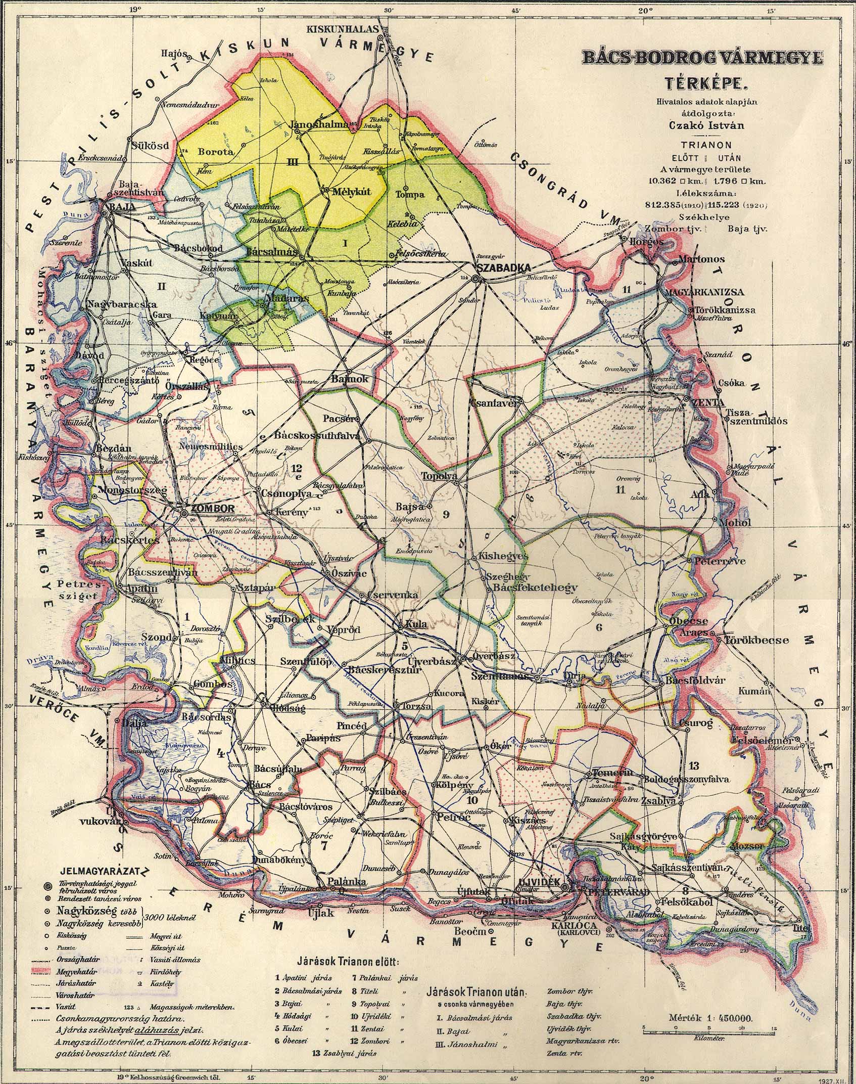
Czakó, István. 1927. “Bács-Bodrog Vármegye Térképe [Bacs-Bodrog County Map].” http://lazarus.elte.hu/hun/maps/1910/bacsbod.jpg.
Deutschland Einwandererzentralstelle. 1939. “EinWanderungsZentralstelle (EWZ) Film Series: 50, 51, 53, 58 Index.” The National Archives and Records Administration. http://www.blackseagr.org/blksea-db/searchform.php
“Donauschwaben Villages Helping Hands.” n.d. Historical Society. Donauschwaben Villages Helping Hands. Accessed September 20, 2021. https://www.dvhh.org/.
“East European Genealogical Society.” n.d. Historical Society. East European Genealogical Society. Accessed September 15, 2021. https://eegsociety.org.
Ehrich, Roger. n.d. “Odessa Digital Library.” Odessa Digital Library. Accessed September 15, 2021. http://odessa3.org/.
Ehrman, Harold. n.d. “Glueckstal.” Google MyMap (online). https://www.google.com/maps/d/viewer?mid=1wjymKz4j1CwEiGCYZxhqDgBp1Vw.
“Eighteenth and Nineteenth Century Primary German Villages of the Volga Region (Map Three).” n.d. Fargo, N.D: Germans from Russia Heritage Collection, North Dakota State University Libraries.
“Europe in the XIX. century.” 1800. Arcanum Adatbázis Kft. https://maps.arcanum.com/en/map/europe-19century-secondsurvey/?layers=158%2C164&bbox=138198.14713959862%2C5670863.733537803%2C2339584.5617526746%2C6481707.729586952.
“Europe in the XIX. century (with the Third Military Survey).” 1800. Arcanum Adatbázis Kft. https://maps.arcanum.com/en/map/europe-19century-thirdsurvey/?layers=160%2C166&bbox=138198.14713959862%2C5670863.733537803%2C2339584.5617526746%2C6481707.729586952.
“Europe in the XVIII. century.” 1700. Arcanum Adatbázis Kft. https://maps.arcanum.com/en/map/europe-18century-firstsurvey/?layers=163%2C165&bbox=138198.14713959862%2C5670863.733537803%2C2339584.5617526746%2C6481707.729586952.
Evans, Nicholas J. 2012. “The Port Jews of Libau, 1880-1914.” Jewish Culture and History 7 (1–2): 197–214.
“Forced Labour Camps and Mass Deportation Areas.” 1947. 159084077. National Archives and Records Administration. https://catalog.archives.gov/id/159084077.
“Formation of the German Population of the Omsk Region [ФОРМИРОВАНИЕ НЕМЕЦКОГО НАСЕЛЕНИЯ ОМСКОЙ ОБЛАСТИ].” n.d. Rusdeutsch.ru. https://siedlung.rusdeutsch.ru/ru/Siedlungsgebiete/Gebiet_Omsk. (archived link - https://web.archive.org/web/20180202072816/https://siedlung.rusdeutsch.ru/ru/Siedlungsgebiete/Gebiet_Omsk)
“Foundation for East European Family History Studies.” n.d. Foundation for East European Family History Studies. Accessed September 15, 2021. https://feefhs.org/.
Freeman, Margaret, Gwen Pritzkau, and Thomas A. Stangl. 2021. “Points-of-Origin: Alphabetical List of Glückstal Colonies Inhabitants.” Glückstal Colonies Research Association.
“Galizien German Descendants.” n.d. Historical society. Galizien German Descendants. Accessed September 15, 2021. https://galiziengermandescendants.org/cms/index.php/en/.
“GeoNames.” n.d. GeoNames. Accessed September 13, 2021. https://www.geonames.org/.
“Germans from Russia Heritage Collection.” n.d. Germans from Russia Heritage Collection. Accessed September 15, 2021. https://library.ndsu.edu/grhc/.
Germans from Russia Heritage Society. 2007. “The St. Petersburg Parish Extraction Projects.” Germans from Russia Heritage Society. http://www.grhs.org/vr/stpete_projects.pdf (archived link - https://web.archive.org/web/20160802071848/http://www.grhs.org/vr/stpete_projects.pdf)
“Germans from Russia Heritage Society.” n.d. Historical Society. Germans from Russia Heritage Society. Accessed September 15, 2021a. https://www.grhs.org/pages/home.
Germans from Russia Heritage Society. n.d. “Johannestal Births - 1905 - File 484-1-2355.” Germans from Russia Heritage Society. Accessed January 23, 2019b. https://grhs.org.
Giesinger, Adam. 1984. “The Autobiography of Peter Sinner.” Journal of the American Historical Society of Germans from Russia 7 (2): 25–31.
Giesinger, Adam. 1993. From Catherine to Khrushchev: The Story of Russia’s Germans. Lincoln, Nebr.: American Historical Society of Germans from Russia. http://www.worldcat.org/oclc/613472561.
“Global Anabaptist Mennonite Encyclopedia Online (GAMEO).” n.d. Accessed September 15, 2021. https://gameo.org/index.php?title=Special:AllPages&from=M&to=N.
“Global Gazetteer Version 2.3.” 2017. Falling Rain. 2017. http://www.fallingrain.com/world/.
“Google Maps.” n.d. Google Maps. Accessed September 18, 2021. https://www.google.com/.
Gray, Gayla. 2008. “Koblenz Questions and Answers.” Black Sea German Research. 2008. https://www.blackseagr.org/research/koblenz-qa.html.
Height, Joseph S. 1973. Paradise on the Steppe: A Cultural History of the Kutschurgan, Beresan, and Liebental Colonists ; 1804-1972. Bismarck, ND: Germans from Russia Heritage Society. http://www.worldcat.org/oclc/634117941.
Height, Joseph S. 1975. Homesteaders on the Steppe: Cultural History of the Evangelical-Lutheran Colonies in the Region of Odessa : 1804-1945. Bismarck, ND: Germans from Russia Heritage Society. http://www.worldcat.org/oclc/219558524.
Heli, Richard. n.d. “A Genealogy Page by Richard Heli - Alsace, the Batschka & the Ukraine.” Rick Heli: Writings and Compilations on History, Language, Books, Music, Genealogy and More. https://rick-heli.info/gene/.
Hollinger, Olaf. 2022. “Naslawtscha.” Bessarabiendeutscher Verein eV. December 8, 2022. https://web.archive.org/web/20221208221735/https://www.bessarabien.de/upload/Naslawtscha_BV.pdf (archived link).
Ilyn, Alexey Afinogenovich. 1871. “[1871] Map of the Orenburg and Ufa province from the atlas of the Russian Empire by Ilyn.” EtoMesto. 1871. http://www.etomesto.com/map-orenburg_1871ilyin/.
“Index from the State Archives of Odessa Oblast of Records Contained in Fond 6 and Fond 252.” 1996. Journal of the American Historical Society of Germans from Russia 19 (3): 17.
Janzen, Tim. 2019. “Compilation of Mennonite Villages in Russia.” Edited by Richard D. Thiessen. Mennonite Genealogical Resources, https://www.mennonitegenealogy.com/. https://www.mennonitegenealogy.com/russia/Compilation_of_Mennonite_Villages_in_Russia.pdf.
* “JewishEncyclopedia.com.” 1906. https://www.jewishencyclopedia.com/.
* JewishEncyclopedia.com. n.d. “Agricultural Colonies in Russia.” Accessed September 11, 2025. https://www.jewishencyclopedia.com/articles/908-agricultural-colonies-in-russia#anchor8.
* JewishGen. 2024. “Agricultural Colonies List:Includes Adjacent Towns and Villages (Marked *) by Name, by Location, by Colonists Origin (Shtetlinks).” https://www.shtetlinks.jewishgen.org/Colonies_of_Ukraine/colonies.html.
“JewishGen KehilaLinks.” n.d. Accessed September 15, 2021. https://kehilalinks.jewishgen.org/.
Kary, Michael E. 2021. “A Historical Narrative of Kary: Following One Line of Kary Lineage from 1650 to the Present, Part 2.” Heritage Review 51 (2).
Kepecs, József, Zoltán Czibulka, Magyarország, and Központi Statisztikai Hivatal. 1999. A Délvidék Településeinek Vallási Adatai, 1880-1941 [Religious Data of the Settlements of the Southern Region 1880-1941]. Budapest: Központi Statisztikai Hivatal. Az előszó és a tartalomjegyzék angol nyelven is.
Kessler, Joseph Aloysius. 2020. “History of the Diocese of Tyraspol (Part 15 - Final).” Translated by Wilhelm Gutsche Horst. Heritage Review 50 (4): 37–44.
Kilba, Irina. 2014. “Deutsche Kolonien Bei Sankt-Petersburg Und Nowgorod 1765-1941 [German Colonies near Saint-Petersburg and Novgorod 1765-1941].” Deutsche Kolonien Bei Sankt-Petersburg Und Nowgorod 1765-1941 [German Colonies near Saint-Petersburg and Novgorod 1765-1941]. 2014. https://web.archive.org/web/20190621163612/http://deutsche-kolonien-spb.com/index.php/ru (archived link)
Konrad, Allen E. 2013. “Dobrudscha Villages: Villages in Dobrudscha with German Families in 1940.” Black Sea German Research. http://www.blackseagr.org/pdfs/konrad/Dobrudscha%20Villages.pdf.
Konrad, Allen E., trans. 2014. “Alphabetical List of Villages in Dobrudscha - 1937.” Black Sea German Research. http://www.blackseagr.org/pdfs/konrad/Alphabetical%20List%20of%20Villages%20in%20Dobrudscha%20-%201937.pdf.
Konrad, Allen E. 2014. “Heimatbuch Der Deutschen Aus Russland [1969-72]: Die Kirchen Und Das Religiöse Leben Der Russlanddeutschen [Home Book of the Germans from Russia (1969-72): The Churches and the Religious Life of the Russian Germans.” Germans from Russia Heritage Society. http://grhs.org/korners/memonly/konrad_doc/Church_Life_GRs.PDF [URL no longer functions].
Kryzhin, I. 1864. “[1864] Map of the Kalmyk Steppe of the Astrakhan Province.” EtoMesto. 1864. http://www.etomesto.ru/map-kalmykiya_1864/.
Langhans, Paul. 1897. “Deutscher Kolonial-Atlas. 30 Karten mit 300 Nebenkarten, entworfen, bearbeitet und herausgegeben von Paul Langhans. [German colonial atlas. 30 maps with 300 In addition to maps, designed, edited and published by Paul Langhans.].” Gotha: Justus Perthes. https://bit.ly/langhans-atlas.
Leibniz Institute for East and Southeast European Research (IOS). 2019. “GeoPortOst.” Geo-referenced maps. GeoPortOst. 2019. http://geoportost.ios-regensburg.de/.
“List of Ukrainian Toponyms That Were Changed as Part of Decommunization in 2016.” n.d. In Wikipedia. Accessed September 14, 2021. https://en.wikipedia.org/w/index.php?title=List_of_Ukrainian_toponyms_that_were_changed_as_part_of_decommunization_in_2016&oldid=1041078298.
“List of Ukrainian Toponyms That Were Changed as Part of Derussification.” 2024. In Wikipedia. https://en.wikipedia.org/w/index.php?title=List_of_Ukrainian_toponyms_that_were_changed_as_part_of_derussification&oldid=1264974069. (Ukrainian https://w.wiki/ChFQ)
Mai, Brent. n.d. “Volga German Institute.” Historical society. Volga German Institute. Accessed December 24, 2023. https://volgagermaninstitute.org/.
“Maps and Historical Notes Related to Mennonite History by William Schroeder, Winnipeg.” n.d. Accessed September 13, 2021. https://www.mharchives.ca/holdings/Schroeder_maps/.
“Map of the Kuban region and the adjacent Black Sea province and part of the Sukhumi district. Compiled by the active member of the Kuban regional statistical committee N.S. Ivanenkov, assistant to the manager of the Kuban regional drawing office. The map was drawn from November 10, 1900 to August 20, 1902. Scale 1:420000 (1 cm = 4.2 km or 10 versts per inch)” [Карта Кубанской области...] 1902. http://www.etomesto.ru/map-kuban_1902-ivanenkov/.
Mergenthaler, A. and Verband der Russlanddeutschen. 1936. “Die deutschen Kolonien an der Wolga; Autonome Sozialistische Sowjetrepublik der Wolgadeutschen nach der Volkszählung von 1926. [The German colonies on the Volga; Autonomous Soviet Socialist Republic of the Volga Germans according to the 1926 census.].” Berlin: Verband der Russlanddeutschen. http://www.worldcat.org/oclc/3248041.
Mertens, Ulrich, Allyn Brosz, Alex Herzog, Thomas Stangl, and Germans from Russia Heritage Collection. 2010. German-Russian Handbook: A Reference Book for Russian German and German Russian History and Culture with Place Listings of Former German Settlement Areas. PDF (searchable, Open). Fargo, N.D: Germans from Russia Heritage Collection, North Dakota State University Libraries. https://hdl.handle.net/10365/32028.
Moiseev, B. A. 2013. Local Names of the Orenburg Region: Historical and Toponymic Essays [Местные Названия Оренбургской Области: Историко-топонимические очерки]. Orenburg, Russia: Orenburg State Pedagogical University Publishing House. http://vestospu.ru/archive/2015/moiseev2013.pdf.
Nachtigal, Reinhard. 2021. “Germans in the Towns of Tsarist Russia and the Early Soviet State.” Presented at the 51st International Convention of the American Historical Society of Germans from Russia, virtual conference, July 15.
“Német-Palánka and Kulpin (Ungarn).” 1881. http://geoportost.ios-regensburg.de/viewer/BV042104313.
Neuer Haus- Und Landwirtschaftskalender Für Deutsche Ansiedler Im Südlichen Russland. 1906 [New House and Agricultural Calendar for German Settlers in Southern Russia. 1906]. 1906. Odessa: Nitzsche. https://nbn-resolving.org/urn:nbn:de:bvb:355-ubr13400-7
Neuer Haus- Und Landwirtschaftskalender Für Deutsche Ansiedler Im Südlichen Russland. 1909 [New House and Agricultural Calendar for German Settlers in Southern Russia. 1909]. 1909. Odessa: Nitzsche. https://nbn-resolving.org/urn:nbn:de:bvb:355-ubr13723-7
Neuer Haus- Und Landwirtschaftskalender Für Deutsche Ansiedler Im Südlichen Russland. 1910 [New House and Agricultural Calendar for German Settlers in Southern Russia. 1910]. 1910. Odessa: Nitzsche. https://nbn-resolving.org/urn:nbn:de:bvb:355-ubr13722-2
Nistor, Ion. 1910. “Ethnographische Landkarte der Bukowina nach der Volkszählung von 1910 [Ethnographic map of Bukovina according to the 1910 census].” Bucharest: Lito Göbl-Rasidescu. https://photos.app.goo.gl/MJCH9EnkcNX9gCCt9.
Nour, Alexis. 1919. “Basarabia: harta etnografica [Bessarabia: ethnographic map].” Bucharest: C. Göbl.-Rasidescu. https://collections.lib.uwm.edu/digital/collection/agdm/id/3439.
Odesa Region State Administration, and State Archives of Odessa Region. 2011. “Зведений Каталог Метричних Книг Випуск І 1797-1939 [Consolidated Catalog of Metric Books, Issue 1, 1797-1939].” Press Courier. Odesa State Archive.
Österreich and Statistische Zentralkommission. 1907. “Gemeindelexikon der im Reichsrate vertretenen Königreiche und Länder [Municipal Encyclopedia of the Kingdoms and Lands Represented in the Imperial Council],” Gemeindelexikon der im Reichsrate vertretenen Königreiche und Länder, https://wiki.genealogy.net/Gemeindelexikon_der_im_Reichsrate_vertretenen_K%C3%B6nigreiche_und_L%C3%A4nder
Parey, Paul. 1979. “Das Deutsche Siedlungsgebiet in Polnisch-Wolhynien. [The German Settlement Area in Polish Volhynia.].” Lincoln, Neb.: American Historical Society of Germans from Russia. http://www.worldcat.org/oclc/650842783.
Petrenko, Iryna. 2015. “Німецькі Колонії На Полтавщині [German Colonies in the Poltava Region].”
Piadyshev, Vasilii Petrovich. 1829. “Generalnaia Karta Astrakhanskoi Gubernii = Carte Generale Du Gouvernement d’Astrakhan [General Map of the Astrakhan Government].” David Rumsey Map Collection. 1829. https://www.davidrumsey.com/luna/servlet/detail/RUMSEY~8~1~288423~90060107:Generalnaia-karta-Astrakhanskoi-gub.
Piadyshev, Vasilii Petrovich. 1829. “Generalnaia Karta Bessarabskoi Oblasti = Carte Generale de La Province de Bessarabie [General Map of the Province of Bessarabia].” David Rumsey Map Collection. 1829. https://www.davidrumsey.com/luna/servlet/detail/RUMSEY~8~1~288395~90060079:Generalnaia-karta-Bessarabskoi-Obla.
Piadyshev, Vasilii Petrovich. 1829. “Generalnaia Karta Chernigovskoi Gubernii = Carte Generale Du Gouvernement de Tchernigow [General Map of the Government of Chernigov].” David Rumsey Map Collection. 1829. https://www.davidrumsey.com/luna/servlet/detail/RUMSEY~8~1~288401~90060085:Generalnaia-karta-Chernigovskoi-gub.
Piadyshev, Vasilii Petrovich. 1829. “Generalnaia Karta Ekaterinoslavskoi Gubernii = Carte Generale Du Gouvernement d’Ekaterinoslaw [General Map of the Ekaterinoslav Government].” David Rumsey Map Collection. 1829. https://www.davidrumsey.com/luna/servlet/detail/RUMSEY~8~1~288404~90060088:Generalnaia-karta-Ekaterinoslavskoi.
Piadyshev, Vasilii Petrovich. 1829. “Generalnaia Karta Kazanskoi Gubernii = Carte Generale Du Gouvernement de Kazan [General Map of the Kazan Government].” David Rumsey Map Collection. 1829. https://www.davidrumsey.com/luna/servlet/detail/RUMSEY~8~1~288419~90060103:Generalnaia-karta-Kazanskoi-guberni.
Piadyshev, Vasilii Petrovich. 1829. “Generalnaia Karta Khersonskoi Gubernii = Carte Generale Du Gouvernement Du Knerson (sic) [General Map of the Kherson Government].” David Rumsey Map Collection. 1829. https://www.davidrumsey.com/luna/servlet/detail/RUMSEY~8~1~288396~90060080:Generalnaia-karta-Khersonskoi-guber.
Piadyshev, Vasilii Petrovich. 1829. “Generalnaia Karta Kievskoi Gubernii = Mappa Generalna Gubernii Kijowskiey [General Map of Kyiv Governorate].” David Rumsey Map Collection. 1829. https://www.davidrumsey.com/luna/servlet/detail/RUMSEY~8~1~288394~90060078:Generalnaia-karta-Kievskoi-gubernii.
Piadyshev, Vasilii Petrovich. 1829. “Generalnaia Karta Nizhegorodskoi Gubernii = Carte Generale Du Gouvernement de Nischnii Novgorod [General Map of the Goverrnment of Nishini Nowgorod].” David Rumsey Map Collection. 1829. https://www.davidrumsey.com/luna/servlet/detail/RUMSEY~8~1~288417~90060101:Generalnaia-karta-Nizhegorodskoi-gu.
Piadyshev, Vasilii Petrovich. 1829. “Generalnaia Karta Novgorodskoi Gubernii = Carte Generale Du Gouvernement de Nowgorod [General Map of the Government of Nowogorod].” David Rumsey Map Collection. 1829. https://www.davidrumsey.com/luna/servlet/detail/RUMSEY~8~1~288397~90060081:Generalnaia-karta-Novgorodskoi-gube.
Piadyshev, Vasilii Petrovich. 1829. “Generalnaia Karta Orenburgskoi Gubernii = Carte Generale Du Gouvernement d’Orenbourg [General Map of the Government of Orenburg].” David Rumsey Map Collection. 1829. https://www.davidrumsey.com/luna/servlet/detail/RUMSEY~8~1~288430~90060114:Generalnaia-karta-Orenburgskoi-gube.
Piadyshev, Vasilii Petrovich. 1829. “Generalnaia Karta Penzenskoi Gubernii = Carte Generale Du Gouvernement de Penza [General Map of Penza Government].” David Rumsey Map Collection. 1829. https://www.davidrumsey.com/luna/servlet/detail/RUMSEY~8~1~288418~90060102:Generalnaia-karta-Penzenskoi-gubern.
Piadyshev, Vasilii Petrovich. 1829. “Generalnaia Karta Permskoi Gubernii = Carte Generale Du Gouvernement de Perm [General Map of the Government of Perm].” David Rumsey Map Collection. 1829. https://www.davidrumsey.com/luna/servlet/detail/RUMSEY~8~1~288429~90060113:Generalnaia-karta-Permskoi-gubernii.
Piadyshev, Vasilii Petrovich. 1829. “Generalnaia Karta Podolskoi Gubernii = Mappa Generalna Gubernii Podolskiey [General Map of the Podolia Governorate].” David Rumsey Map Collection. 1829. https://www.davidrumsey.com/luna/servlet/detail/RUMSEY~8~1~288382~90060066:Generalnaia-karta-Podolskoi-Guberni.
Piadyshev, Vasilii Petrovich. 1829. “Generalnaia Karta Poltavskoi Gubernii = Carte Generale Du Gouvernement de Poltawa [General Map of the Government of Poltava].” David Rumsey Map Collection. 1829. https://www.davidrumsey.com/luna/servlet/detail/RUMSEY~8~1~288402~90060086:Generalnaia-karta-Poltavskoi-gubern.
Piadyshev, Vasilii Petrovich. 1829. “Generalnaia Karta Sanktpeterburgskoi Gubernii = Carte - Generale Du Gouvernement de St. Petersburg [General Map of the Government of Saint Petersburg].” David Rumsey Map Collection. 1829. https://www.davidrumsey.com/luna/servlet/detail/RUMSEY~8~1~288389~90060073:Generalnaia-karta-Sanktpeterburgsko.
Piadyshev, Vasilii Petrovich. 1829. 1829p. “Generalnaia Karta Saratovskoi Gubernii = Carte Generale Du Gouvernement de Saratow [General Map of the Saratov Government].” David Rumsey Map Collection. 1829. https://www.davidrumsey.com/luna/servlet/detail/RUMSEY~8~1~288421~90060105:Generalnaia-karta-Saratovskoi-guber.
Piadyshev, Vasilii Petrovich. 1829. 1829q. “Generalnaia Karta Simbirskoi Gubernii = Carte Generale Du Gouvernement de Simbirsk [Map of the General Government of Simbirsk].” David Rumsey Map Collection. 1829. https://www.davidrumsey.com/luna/servlet/detail/RUMSEY~8~1~288420~90060104:Generalnaia-karta-Simbirskoi-gubern.
Piadyshev, Vasilii Petrovich. 1829. 1829r. “Generalnaia Karta Slobodskoi Ukrainskoi Gub. = Carte Generale Du Gouvt. Slobodsko Oukrainskaia [General Map of the Government of Slobodskoi Ukrainskoi, Later Kharkov Province].” David Rumsey Map Collection. 1829. https://www.davidrumsey.com/luna/servlet/detail/RUMSEY~8~1~288403~90060087:Generalnaia-karta-Slobodskoi-Ukrain.
Piadyshev, Vasilii Petrovich. 1829. 1829s. “Generalnaia Karta Tavricheskoi Gubernii = Carte Generale Du Gouvernement de La Tauride [General Map of the Government of Taurida].” David Rumsey Map Collection. 1829. https://www.davidrumsey.com/luna/servlet/detail/RUMSEY~8~1~288405~90060089:Generalnaia-karta-Tavricheskoi-gube.
Piadyshev, Vasilii Petrovich. 1829. 1829t. “Generalnaia Karta Tsarstva Polskago = Mappa Generalna Krolestwa Polskiego [General Map of Congress Poland].” David Rumsey Map Collection. 1829. https://www.davidrumsey.com/luna/servlet/detail/RUMSEY~8~1~288381~90060065:Generalnaia-karta-Tsarstva-Polskago.
Piadyshev, Vasilii Petrovich. 1829. 1829u. “Generalnaia Karta Viatskoi Gubernii = Carte Generale Du Gouvernement de Wiatka [General Map of the Government of Vyakta].” David Rumsey Map Collection. 1829. https://www.davidrumsey.com/luna/servlet/detail/RUMSEY~8~1~288416~90060100:Generalnaia-karta-Viatskoi-gubernii.
Piadyshev, Vasilii Petrovich. 1829. 1829v. “Generalnaia Karta Volynskoi Gubernii = Mappa Generalna Gubernii Wolynskiey [General Map of the Volyn Governorate].” David Rumsey Map Collection. 1829. https://www.davidrumsey.com/luna/servlet/detail/RUMSEY~8~1~288383~90060067:Generalnaia-karta-Volynskoi-Guberni.
Piadyshev, Vasilii Petrovich. 1829. 1829w. “Generalnaia Karta Voronezhskoi Gubernii = Carte Generale Du Gouvernement de Woroniege [General Map of the Government of Voronezh].” David Rumsey Map Collection. 1829. https://www.davidrumsey.com/luna/servlet/detail/RUMSEY~8~1~288415~90060099:Generalnaia-karta-Voronezhskoi-gube.
Pohl, J. Otto. 2008. “Otto’s Random Thoughts: Volga German Settlements in Turkmenistan.” Otto’s Random Thoughts (blog). February 6, 2008. https://jpohl.blogspot.com/2008/02/volga-german-settlements-in.html.
* Presidential Library of the Russian Federation. n.d. “Complete Code of Laws of the Russian Empire [Полное Собрание Законов Российской Империи].” https://www.prlib.ru/en/section/681951.
Ratliff, Walter. n.d. “Great Mennonite Trek to Central Asia.” Google MyMap (online). https://www.google.com/maps/d/viewer?mid=1h649LqdaC5xQNpY4o6tm6_n_JSk&hl=en.
Ratliff, Walter. 2008. “Mennonite Life - Spring 2008 - Ratliff Article.” Last Oasis: The Mennonite Refuge in Khiva. 2008. https://mla.bethelks.edu/ml-archive/2008summer/ratliff.php.
Richter, I. A., and N. F. Stanevich. 1867. “Map of the Samara Province of 1867 by Richter and Stanevich.” EtoMesto. 1867. http://www.etomesto.com/map-samara_1867-guberniya/.
Rudolf, Homer, ed. 2004. The Glückstalers in New Russia and North America: A Bicentennial Collection of History, Genealogy and Folklore. Redondo Beach, CA: Glückstal Colonies Research Association. http://www.worldcat.org/oclc/56674103.
Rudolf, Homer, ed. 2008. The Glückstalers in New Russia, the Soviet Union, and North America. Redondo Beach, CA: Glückstal Colonies Research Association. http://www.worldcat.org/oclc/259112611.
“Russia (1872).” 1872. Arcanum Adatbázis Kft. https://maps.arcanum.com/en/map/russia-1872/?layers=14&bbox=3037301.75593975%2C7136947.575453242%2C3106095.0813964084%2C7162286.450329779.
“Russische Eroberungen in Zentral-Asien [Russian conquests in Central Asia].” 1906. Leipzig: Bibliographisches Institut. http://alabamamaps.ua.edu/historicalmaps/asia/index2_1906-1910.htm.
“Russo-Ukrainian War.” n.d. Google My Maps. https://www.google.com/maps/d/viewer?mid=1lscRK6ehG0l2V-XvJ16nsyblMsQ.
Sapago, Larisa. 2012. “Zigzags of Fate and Time [Зигзаги Судьбы И Времени].” «Слово Кыргызстана» [Slovo Kyrgyzstana or The Word of Kyrgyzstan], March 12, 2012. https://archive.slovo.kg/?p=7262.
Schilling Payne, Sandy. 2019. “Survey: Germans from Russia in America.” Germans from Russia Settlement Locations in America. 2019. https://america.germansfromrussiasettlementlocations.org/the-survey.
Schlau, Frieda. 1989. “The German Settlements in the Belovezh Parish in Chernigov Province.” Translated by Edward R. Brandt. Journal of the American Historical Society of Germans from Russia 12 (2): 7–17.
Schnurr, Joseph. 1978. Die Kirchen und das religiöse Leben der Rußlanddeutschen. Evangelischer Teil. [The Churches and Religious Life of the Russian Germans. Protestant part.]. Stuttgart: AER Verlag Landsmannschaft der Deutschen aus Rußland. http://www.worldcat.org/oclc/634583604.
Schnurr, Joseph. 1980. Die Kirchen und das religiöse Leben der Russlanddeutschen. Katholik Teil. [The Churches and Religious Life of the Russian Germans. Catholic part.]. Stuttgart: Selbstverlag Joseph Schnurr. http://www.worldcat.org/oclc/614972561.
Schreiber, Steve. 2021. “Norka: Deportation 1941.” NORKA. 2021. https://www.norkarussia.info/deportation-1941.html.
Schroeder, William, and Helmut T Huebert. 1996. Mennonite Historical Atlas. Second Edition. Winnipeg, Manitoba, Canada: Springfield Publishers.
Schubert. 1860. “1860 Европейская Россия (Шуберт) v.1 [European Russia (Schubert) v.1].” http://retromap.ru/14186010.
Schubert. 1872. “1872 Европейская Россия (Шуберт) v.2 [European Russia (Schubert) v.2].” http://retromap.ru/1418726.
Silantʹeva, Olʹga and Meždunarodnyj Sojuz Nemeckoj Kul’tury. 2011. “Fortjagen muss man sie.” Zeitzeugen und Forscher berichten über die Tragödie der Russlanddeutschen. 2016th ed. Moscow, Russia: Moskva MSNK-Press. http://www.worldcat.org/oclc/794532115.
“Society for German Genealogy in Eastern Europe.” n.d. Society for German Genealogy in Eastern Europe. Accessed September 15, 2021. https://sggee.org/.
Society for German Genealogy in Eastern Europe (SGGEE). n.d. “SGGEE Master Pedigree Database.” Society for German Genealogy in Eastern Europe. Accessed September 15, 2021. https://sggee.org/.
Society for German Genealogy in Eastern Europe. 2021. “[SGGEE] Mennonitische Orte in SGGEE Gazetteers 20210825.” Society of German Genealogy in Eastern Europe. https://www.sggee.org/research/Gazetteer_Mennonite_villages.pdf.
Spack, Alexander. n.d. “WolgaDeutsche Lexicon.” WolgaDeutsche. Accessed February 7, 2023. https://lexikon.wolgadeutsche.net/.
Stambul, Nisan Amitai, and Society of Emigrants from Akkerman and Vicinity. n.d. “Akkerman and the Towns of Its District; Memorial Book.” JewishGen. Accessed September 15, 2021. https://www.jewishgen.org/yizkor/akkerman/Akkerman.html#TOC272.
Stewner, Frank. 2012. “SGGEE Volhynian Gazetteer.” Society of German Genealogy in Eastern Europe. https://www.sggee.org/research/Gazetteer_Volhynia.pdf.
Stewner, Frank. 2012. “SGGEE Congress-Poland Gazetteer.” Society of German Genealogy in Eastern Europe. https://www.sggee.org/research/Gazetteer_Congress_Poland.pdf.
Stewner, Frank. 2019. “SGGEE Russia Empire Gazetteer Remaining Countries.” Society of German Genealogy in Eastern Europe. https://www.sggee.org/research/Gazetteer_Russian_Empire.pdf.
Stewner, Frank. 2019. “SGGEE Russia Gazetteer.” Society of German Genealogy in Eastern Europe. https://www.sggee.org/research/Gazetteer_Russia.pdf.
Stewner, Frank. 2019. “SGGEE Ukrainian Gazetteer Other Oblasts.” Society of German Genealogy in Eastern Europe. https://www.sggee.org/research/Gazetteer_Ukraine.pdf.
Stumpp, Karl. 1954. “Map of the German Colonies of the Belovezh District in the Province of Chernigov.” http://www.bechthold.org/genealogy/Belovezh.jpg.
Stumpp, Karl. 1955. “Karte der deutschen Siedlungen im Gebiet (Oblast) Odessa: (ehem. westl. Teil des Gouv. Cherson.) [Map of German settlements in the Odessa region/oblast, former western part of Kherson governorate].” Greeley, CO: American Historical Society of Germans from Russia and Landsmannschaft der Deutschen aus Russland. http://www.worldcat.org/oclc/13217694.
Stumpp, Karl. 1957. “Karte der deutschen Siedlungen im Gebiet (Oblast) Dnjepropetrowsk: (ehem. nördl. Teil des Gouv. Jekaterinoslaw), einschl. der deutschen Dörfer im westlichen Teil des Gebiets Charkow [Map of German settlements in Dnipropetrovsk Oblast (former northern part of Ekaterinoslav Governorate), including German villages in the western part of Kharkov Oblast].” Lincoln, NE: American Historical Society of Germans from Russia and Landsmannschaft der Deutschen aus Russland. http://www.worldcat.org/oclc/13217710.
Stumpp, Karl. 1957. “Karte der deutschen Siedlungen im Gebiet (Oblast) Nikolajew (ehem. Gouv. Cherson): einschliesslich der wenigen deutschen Dörfer im Gebiet Kirowograd [Map of German settlements in Nikolaev Oblast (former Kherson Governorate): including the few German villages in Kirovograd Oblast].” Lincoln, NE: American Historical Society of Germans from Russia and Landsmannschaft der Deutschen aus Russland. http://www.worldcat.org/oclc/13328627.
Stumpp, Karl. 1958. “Karte der deutschen Siedlungen im Gebiet (Oblast) Stalino: (ehem. östl. Teil vom Gouvern. Jekaterinoslaw u. westl. Teil vom Dongebiet) : einschl. der deutschen Dörfer im östl. Teil des Gebiets Charkow [Map of German settlements in Stalino Oblast (former eastern part of Ekaterinoslav Governorate and western part of the Don region): including German villages in the eastern part of Kharkov Oblast.].” Lincoln, NE: American Historical Society of Germans from Russia and Landsmannschaft der Deutschen aus Russland. http://www.worldcat.org/oclc/13328630.
Stumpp, Karl. 1960. “Karte der deutschen Siedlungen im Nord- u. Südkaukasus [Map of German settlements in North and South Caucasus].” Lincoln, NE: American Historical Society of Germans from Russia and Landsmannschaft der Deutschen aus Russland.
Stumpp, Karl. 1961. “Karte der deutschen Siedlungen in den Gouv. St. Petersburg (Leningrad) u. Nowgorod [Map of German settlements in the governorates of St. Petersburg (Leningrad) & Novgorod].” http://www.worldcat.org/oclc/859263691.
Stumpp, Karl. 1964. “Karte der deutschen Siedlungen bzw. Siedlungsgebiete im asiatischen Teil der Sowjetunion: Nord-(Siberien) u. Mittelasien [Map of German settlements or settlement areas in the Asian part of the Soviet Union: North (Siberia) u. Central Asia].” Lincoln, Neb.: American Historical Society of Germans from Russia. http://www.worldcat.org/oclc/793865422.
Stumpp, Karl. 1964. “Karte der deutschen Siedlungen in den Gebieten Omsk, Slawgorod Kulunda-Steppe) Zelinograd (Akmolinsk) [Map of German settlements in the areas of Omsk, Slavgorod (Kulunda-Steppe), Zelinograd (Akmolinsk)].” Lincoln, Neb.: American Historical Society of Germans from Russia. http://www.worldcat.org/oclc/1045614031.
Stumpp, Karl. 1965. “Karte der deutschen Siedlungen in Bessarabien: Stand 1940 [Map of German settlements in Bessarabia as of 1940].” Greeley, CO: American Historical Society of Germans from Russia and Landsmannschaft der Deutschen aus Russland.
Stumpp, Karl. 1970. “Karte der deutschen Siedlungen im Gebiet [Oblast] Rostow [ehem. Dongebiet] einschl. der deutschen Kolonien im Gebiet Woroschilowograd [Map of German settlements in the Rostov Oblast including German colonies in the Voroshilovograd Oblast].” Lincoln, Neb.: American Historical Society of Germans from Russia. http://www.worldcat.org/oclc/255453091.
Stumpp, Karl. 1970. “Karte der deutschen Siedlungen in Neu (Süd)-Rußland [Map of German settlements in New (South) Russia].” Lincoln, Nebr.: American Historical Society of Germans from Russia. http://www.worldcat.org/oclc/248564276.
Stumpp, Karl. 1970. “Karte der deutschen Siedlungen in ukrainisch Wolhynien [Map of German settlements in Ukrainian Volhynia].” Greeley, CO: American Historical Society of Germans from Russia and Landsmannschaft der Deutschen aus Russland. http://www.worldcat.org/oclc/13217695.
Stumpp, Karl. 1971. “Die deutschen Siedlungen auf der Halbinsel Krim [The German settlements on the Crimean peninsula].” Greeley, CO: American Historical Society of Germans from Russia. http://www.worldcat.org/oclc/13217698.
Stumpp, Karl. 1971. “Karte der deutschen Siedlungen im Gebiet Saporoshje: ehem. die Gebiete Taurien u. d. südl. Teil v. Jekaterinoslaw (Dnjepropetrowsk) [Map of German settlements in Zaporozhye region: former Tauria and the southern part of Ekaterinoslav (Dnepropetrovsk).].” Lincoln, NE: American Historical Society of Germans from Russia and Landsmannschaft der Deutschen aus Russland. http://www.worldcat.org/oclc/13217709.
Stumpp, Karl. 1971. “Karte der deutschen Siedlungen im Raum Alt-Samara, Ufa-Dawlekanowo, Orenburg, Neu-Samara und Aktjubinsk [Map of German settlements in the area of Old Samara, Ufa-Davlekanovo, Orenburg, New Samara and Aktyubinsk].” Greeley, CO: American Historical Society of Germans from Russia. http://www.worldcat.org/oclc/13328619.
Stumpp, Karl. 1971. “Karte der deutschen Siedlungen im Wolgagebiet [Map of German settlements in the Volga region].” Greeley, CO: American Historical Society of Germans from Russia and Landsmannschaft der Deutschen aus Russland. http://www.worldcat.org/oclc/13328614.
Stumpp, Karl. 1984. “In the Wake of the German Army on the Eastern Front, August 1941 to May 1942.” Translated by Adam Giesinger. Journal of the American Historical Society of Germans from Russia 7 (4): 17–22.
Stumpp, Karl and American Historical Society of Germans from Russia. 1993. The Emigration from Germany to Russia in the Years 1763 to 1862. Lincoln, Neb.: American Historical Society of Germans from Russia. http://www.worldcat.org/oclc/881444049.
Stumpp, Karl, Deutschland Reichsministerium für die Besetzten Ostgebiete, and Deutsches Ausland-Institut. n.d. “German Captured Documents Collection : Reports from Ethnic German Communities in Ukraine, 1940-1944.” FamilySearch. Accessed September 14, 2021. https://www.familysearch.org/search/catalog/979490?availability=Family%20History%20Library.
Sulkevich. 1931. “Map of the Lower Volga Region.” EtoMesto. 1931. http://www.etomesto.com/map-saratov_1931/.
Tardieu, Pierre François. 1788. “Carte Des Colonies Allemandes Etables Sur Le Volga Dans Le Territoire de Saratov [Map of German Settlements on the Volga River in the Saratov Territory].” https://www.swaen.com/zoomV2.php?id=15523&referer=antique-map-of.php.
Tarkhov, Sergey Anatolievich. 2005. “Изменение административно территориального деления России в XIII—XX вв. [Changes in the administrative and territorial division of Russia in the thirteenth to twentieth centuries].” журнала Логос 46 (1): 65–101. http://www.ruthenia.ru/logos/number/46/03.pdf.
“The Imperiia Project.” 2018. Map. The Imperiia Project. 2018. https://imperiia.omeka.fas.harvard.edu/.
“The Volga Germans.” 2020. The Volga Germans. 2020. https://www.volgagermans.org/.
Tissen, Andreas. 2017. “Mennonitische Orte in Russland [Mennonite places in Russia].” Map. https://www.google.com/maps/d/viewer?mid=1EytDLhxg4lXXNV3HyjtVpc1tDKdr0wLC.
* “Topographic Maps of Eastern Europe.” n.d. Accessed September 11, 2025. https://easteurotopo.org/.
Traeger, Paul. 1922. Die Deutschen in der Dobrudscha [The Germans in Dobruja]. http://www.worldcat.org/oclc/264108115.
Tuffner, Martin, and Jakob Schuy. 1997. Ortssippenbuch Hodschag, 1756-1945 [Local genealogy book Hodschag, 1756-1945]. Friedrichsdorf: Zentralle für Personen- und Familiengeschichte. http://www.worldcat.org/oclc/38043333.
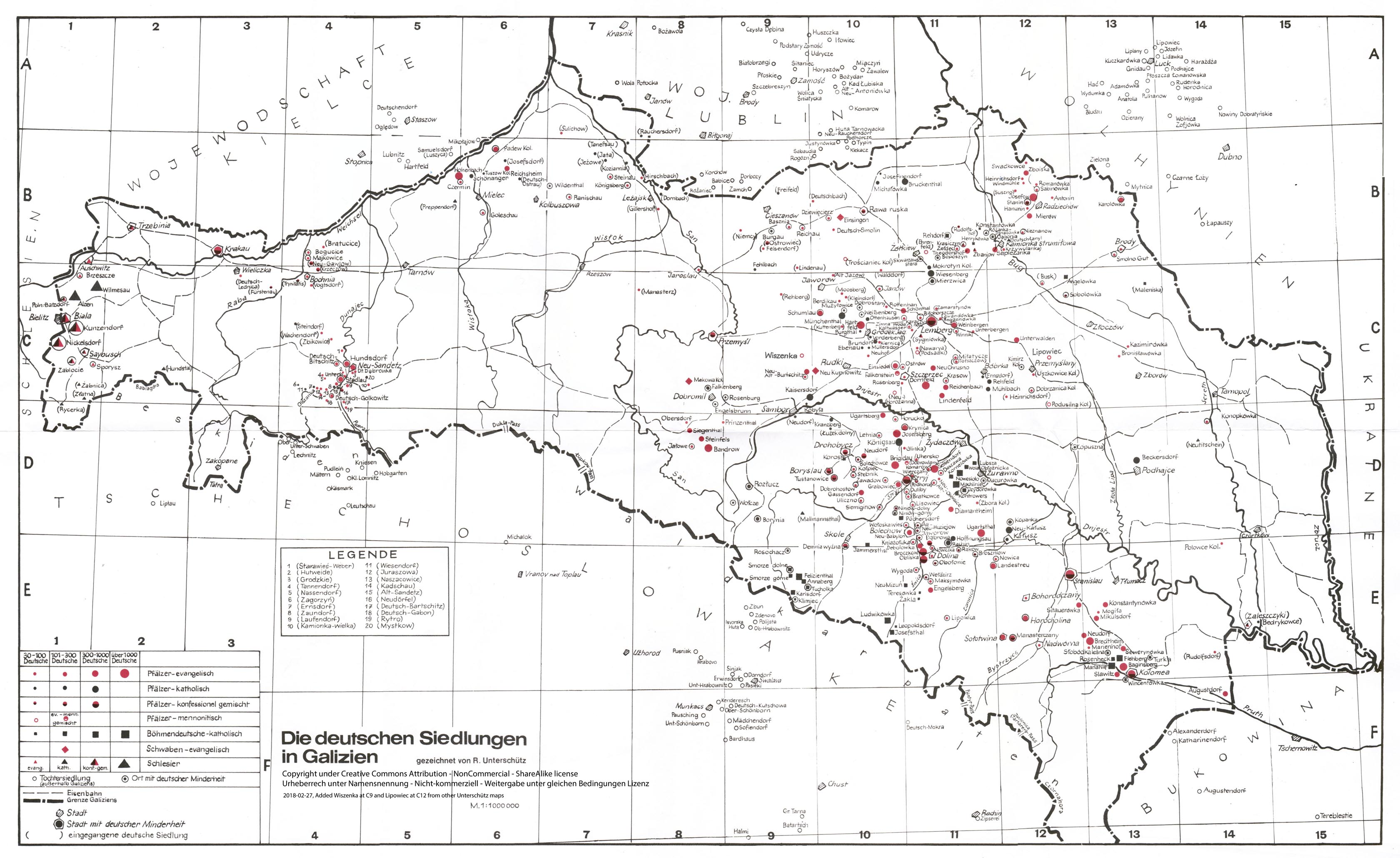
Unterschütz, Rudolph. 2003. “Die deutschen Siedlungen in Galizien Stand 1939 [German settlements in Galicia as of 1939].” Philip Semenchuck. https://semanchuk.com/gen/maps/unterschutz.html.
———. 2017. “Die deutschen Siedlungen in Galizien [The German Settlements in Galicia].” Galizien German Descendants. https://galiziengermandescendants.org/cms/images/Maps/Unterschutz_map_col.jpg.
“Upstream Vistula.” n.d. Accessed September 16, 2021. http://www.upstreamvistula.org/.
U.S. Army Map Service. 1950. “Eastern Europa N501 Army Map Service.” EtoMesto. 1950. http://www.etomesto.com/map-atlas_n501/?y=51.3227&x=47.6385.
“Villages of the Hoffnungstal Parish.” 2008. Germans from Russia Heritage Society. 2008. https://www.grhs.org/chapters/hop/vc.htm.
Vlasenko, Petro. n.d. “Topographic Map of Ukraine, Belarus (Austrian 1910).” Accessed September 15, 2021. https://maps.vlasenko.net/?lat=50.46&lon=30.56&addmap2=smtm1000&s=&addmap1=topo1910.
“Volksfreund Kalender Für Das Jahr 1910.” 1910. Wolgadeutsche. 1910. https://wolgadeutsche.net/bibliothek/kalender/Volksfreund_Kalender_1910.pdf
“Volksfreund Kalender Für Das Jahr 1911.” 1911. Digital Collections of the University Library Regensburg. 1911. http://digital.bib-bvb.de/view/bvb_mets/viewer.0.6.5.jsp?folder_id=0&dvs=1749066141434~896&pid=3514168&locale=en&usePid1=true&usePid2=true
Wahl, Dale Lee. 1999. “German-Russian Village List, i.e., ‘The Long List’ (Odessa3).” Odessa Digital Library. 1999. http://odessa3.org/collections/refs/link/villhelp.txt.
Wahl, Dale Lee, ed. 2003. “Hoffnungstal Parish Villages and Chutors.” The Hoffnungstal Odessa Newsletter 11 (2): 15–16.
Wahl, Dale Lee, and Gayla Aspenleiter. 2019. “German-Russian Village List, i.e., ‘The Long List’ (Black Sea German Research).” Black Sea German Research. 2019. http://www.blackseagr.org/pdfs/village_list.pdf.
Walder, Tony. 2019. “Hutterite Life – History and Social Structure.” Presented at the Germans from Russia Heritage Society 49th Annual Convention, Fargo, N.D, July.
Weigel, Lillian Bachynski. 2008. Kutschurgan Spousal Project: Based on the 1852 Catholic Church Census in the Kutschurgan Villages of Baden, Elsass, Kandel, Mannheim, Selz, and Strassburg. Avon, CT: L. Weigel. http://www.worldcat.org/oclc/459796923.
Wikimedia Toolforge. n.d. “GeoHack.” GeoHack. Accessed September 14, 2021. https://geohack.toolforge.org/.
“Wikipedia (English).” n.d. Encyclopedia. Wikipedia - The Free Encyclopedia. https://www.wikipedia.org/.
“Wikipedia (German).” n.d. Encyclopedia. Wikipedia - The Free Encyclopedia. https://de.wikipedia.org/.
“Wikipedia (Hungarian).” n.d. Encyclopedia. Wikipedia - The Free Encyclopedia. https://hu.wikipedia.org/.
“Wikipedia (Polish).” n.d. Encyclopedia. Wikipedia - The Free Encyclopedia. https://pl.wikipedia.org/.
“Wikipedia (Romanian).” n.d. Encyclopedia. Wikipedia - The Free Encyclopedia. https://ro.wikipedia.org/.
“Wikipedia (Russian).” n.d. Encyclopedia. Wikipedia - The Free Encyclopedia. https://ru.wikipedia.org/.
“Yandex.Maps.” n.d. Yandex.Maps. Accessed September 18, 2021. https://yandex.com/maps/.
Zello. 2015. “Pest-Pilis-Solt-Kiskun Vármegye [Pest-Pilis-Solt-Kiskun County].” Online. Wikimedia Commons. https://commons.wikimedia.org/wiki/File:Pest-Pilis-Solt-Kiskun.png.
Zgursky, Alexander. 2011. “Німецький Острівець у Полтаві [German Island in Poltava].” Інтернет-Видання «Полтавщина», February 5, 2011. https://poltava.to/news/7646/.
Архивные карты. 2011. “Архивные карты [Archived Maps and Atlas Retrospective].” Geo-referenced maps. Архивные карты [Atlas Retrospective]. 2011. http://boxpis.ru/svg/.
As of December 2022, this website was completely gone. It was not archived in the Wayback Machine. Similar maps that were on this site can be found in a number of other sites now including Arcanum (https://maps.arcanum.com/en/map/russia-1872/).
“Еврейские земледельческие колонии Юга Украины и Крыма [Jewish agricultural colonies in the South of Ukraine and Crimea].” 2005. 2005. http://evkol.ucoz.com/.
“Первая Всеобщая Перепись Населения Российской Империи 1897 г. [The First General Census of the Population of the Russian Empire in 1897].” 1897. Demoscope Weekly. 1897. http://www.demoscope.ru/weekly/ssp/census.php?cy=0.
“Реестр немецких поселений России [Register of German Settlements in Russia].” 2014. Narrative gazetteer. Register of German Settlements in Russia. 2014. https://siedlung.rusdeutsch.ru/ru/Siedlungsorte?l=1. (archived link - https://web.archive.org/web/20210918043550/https://siedlung.rusdeutsch.ru/ru/Siedlungsorte?l=1)
# # #