I love finding old maps with the names German colonies on them. It’s like finding a baby picture you never knew was taken. You might think that every map of the Russian Empire has our German colonies on them, but the fact is they don’t. Germans were one of many ethnicities that colonized the Russian Empire, and our settlements in Russia did not always make it onto maps.
Later this summer, I’ll be presenting “Time Travel Using Historical Maps” at the AHSGR Convention in July and at the GR Wall Breaker Conference in September. In preparation, I’ve been gathering up examples and will share some of them leading up to the beginning of convention season.First up, the Bessarabian colony of Artsyz, which is today in Odessa Oblast, Ukraine.
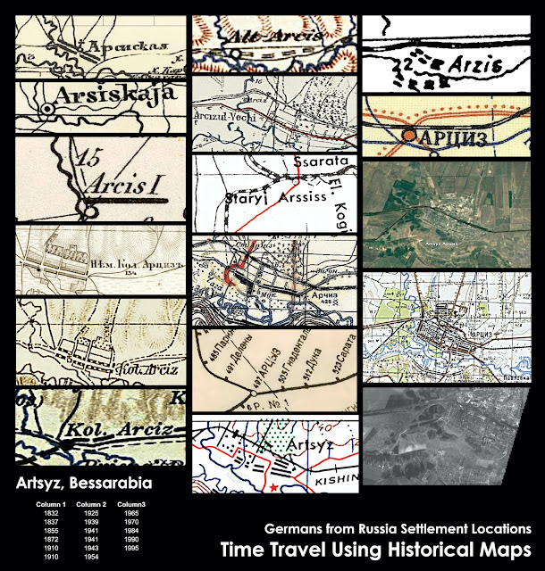
Founded and settled in 1816, Arzis (Alt-Arcis/Arcis/Arciz/Artsyz/Arssis) was originally called “No. 14.” In 1819, according to a document from the Odessa State Archive (Fond 6, Inventory 1, File 1245), the 15 colonies in Bessarabia at that time underwent some name changes. No. 14 was named “Ivanovsky” by the Bessarabia Department of Foreign Settlers and the name “Arzis” by “the highest order.” On this document there is a Post-It (more recent research, obviously) that says, “#14 was named Johanneshort before being named Ivanovsky.” Johannes being the German version of Ivan, that makes sense.
While I was really hoping to find a map that showed Artsyz as Ivanovsky or Johanneshort, I didn’t. The earliest I found was published 1832 from data collected in the years prior. Remember, back then it took many years to survey the land, gather data, draw maps, and have them published and distributed. The exception to this are military maps drawn during an active campaign. Those are often updated from previous campaigns.
During its existence, Artsyz has been historically a part of the Imperial Russian Empire (1816-1917), the Moldavian Democratic Republic (1917-1918), the Kingdom of Romania (1819-1940), the Soviet Union (1940-1941), the Kingdom of Romania again (1941-1944), the Soviet Union again (1944-1991), and Ukraine (1991-present).
The image below shows just a few maps (and a couple early satellite photos) where Artsyz was named. They were drawn/published by Russia, Germany, Austria, Romania, and the United States. Most of the images below are linked to their live historical maps. Click on one and see where it takes you in time.
 |
| To view a static version of this image, click here. |
# # #
Last updated 6 June 2022